Category:Pinus jeffreyi range maps
Jump to navigation
Jump to search
Media in category "Pinus jeffreyi range maps"
The following 8 files are in this category, out of 8 total.
-
 Pinus jeffreyi levila.jpg 1,200 × 900; 125 KB
-
 CL-48 Pinus jeffreyi & Pinus washoensis range map.png 2,286 × 3,580; 5.41 MB
-
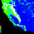 Distribution of Jeffrey pine trees as predicted by Maxent modeling.png 1,351 × 1,376; 540 KB
-
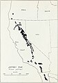 Munns (1938) 014 Pinus jeffreyi.jpg 2,323 × 3,281; 2.41 MB
-
 Pinus jeffreyi range map 0.png 9,624 × 12,505; 1,004 KB
-
 Pinus jeffreyi range map 1.png 3,335 × 3,335; 123 KB
-
 Pinus jeffreyi range map 2.png 2,171 × 2,171; 69 KB
-
 Pinus jeffreyi USGS range map.png 4,812 × 6,253; 477 KB


_014_Pinus_jeffreyi.jpg)


