Category:Phare de l'île Verte
Jump to navigation
Jump to search
 |
This category is for a cultural heritage site in Canada, number 3675
|
This category is for a cultural heritage site in Canada, number 10559
|
This category is for a cultural heritage site in Canada, number 12287
|
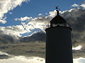
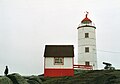
English: Île-Verte Lighthouse is an attractive 12 metre high cylindrical stone lighthouse, with an octagonal painted metal lamp, situated on an island in the St. Lawrence River opposite the mouth of the Saguenay River. Its isolated setting contains not only the tower, but a lightkeeper’s residence, a fog horn building, an oil shed and a small powder magazine.
Français : Le phare de l'Île-Verte est un élégant phare cylindrique en pierre de 12 mètres équipé d’une lanterne octogonale peinte érigé sur une île du fleuve Saint-Laurent, devant l’embouchure de la rivière Saguenay. Outre la tour, ce site isolé inclut aussi une résidence de gardien, un bâtiment abritant la corne de brume, un hangar à pétrole et une petite poudrière.
- Secteur du phare de l'Île-Verte. Répertoire du patrimoine culturel du Québec.
lighthouse in Notre-Dame-des-Sept-Douleurs, Quebec, Canada  | |||||
| Upload media | |||||
| Instance of | |||||
|---|---|---|---|---|---|
| Part of | |||||
| Location | Notre-Dame-des-Sept-Douleurs, Rivière-du-Loup, Bas-Saint-Laurent, Quebec, Canada | ||||
| Located in or next to body of water | |||||
| Heritage designation |
| ||||
| Inception |
| ||||
| Height |
| ||||
 | |||||
Media in category "Phare de l'île Verte"
The following 4 files are in this category, out of 4 total.
-
 Notre-Dame-des-Sept-Douleurs2.jpg 2,048 × 1,536; 656 KB
-
 Pano Notre-Dame-des-Sept-Douleurs.jpg 2,048 × 672; 369 KB
-
 Phare de l'île Verte.JPG 640 × 480; 106 KB
-
 PhareIleVerte.jpg 3,594 × 2,520; 3.25 MB


Categories:
- National Historic Sites of Canada by name
- Lighthouses in Quebec
- Lighthouses in Canada by name
- Built in Canada in 1809
- 1800s architecture in Quebec
- Île Verte (Québec)
- National Historic Sites of Canada in Quebec
- Cultural heritage monuments in Bas-Saint-Laurent
- Municipally designated cultural heritage monuments in Quebec
- Lighthouses built in 1809
- White lighthouses in Canada
- Stone lighthouses in Canada
- Stone buildings in Quebec
- Lighthouses by range, 15 to 19 nm
- Landfall lights