Category:Pfarrkirche hl. Stefan, Grafenstein
Jump to navigation
Jump to search
| Object location | | View all coordinates using: OpenStreetMap |
|---|
church building in Grafenstein, Austria  | |||||
| Upload media | |||||
| Instance of | |||||
|---|---|---|---|---|---|
| Named after | |||||
| Location | Grafenstein, Klagenfurt-Land District, Carinthia, Austria | ||||
| Heritage designation | |||||
 | |||||
Media in category "Pfarrkirche hl. Stefan, Grafenstein"
The following 28 files are in this category, out of 28 total.
-
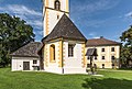
 Grafenstein Kirchplatz Pfarrkirche hl. Stefan 26072018 6019.jpg 2,855 × 4,794; 9.75 MB
-
 Grafenstein Kirchplatz Pfarrkirche hl. Stefan S-Ansicht 26032019 6155.jpg 6,579 × 4,289; 18.68 MB
-
 Grafenstein Kriegerdenkmal und Pfarrkirche hl. Stefan 26072018 4007.jpg 7,360 × 4,912; 31.39 MB
-
 Grafenstein Krkoška-Brunnen Pfarrkirche hl. Stefan und Schloss 2011-09-08 115.jpg 2,802 × 3,401; 2.41 MB
-
 Grafenstein Krkoška-Brunnen vor der Pfarrkirche hl. Stefan 05112011 122.jpg 2,832 × 4,256; 3.03 MB
-
 Grafenstein Krkoška-Brunnen vor der Pfarrkirche hl. Stefan und dem Schloss 05112011 111.jpg 4,256 × 2,832; 3.29 MB
-
 Grafenstein Pfarrkirche hl Stefan Deckenfresko Kreuzabnahme 11122011 466.jpg 4,288 × 2,848; 1.65 MB
-
 Grafenstein Pfarrkirche hl Stefan Taufkapelle Deckenfresko Fusswaschung 08122011 348.jpg 4,288 × 2,848; 1.19 MB
-
 Grafenstein Pfarrkirche hl. Stefan 08092011 111.jpg 2,763 × 3,732; 1.63 MB
-
 Grafenstein Pfarrkirche hl. Stefan N-Ansicht 26072018 4040.jpg 5,853 × 4,864; 18.23 MB
-
 Grafenstein Pfarrkirche hl. Stefan NO-Ansicht 26072018 4011.jpg 4,323 × 5,468; 11.53 MB
-
 Grafenstein Pfarrkirche hl. Stefan Pietà 11122011 452.jpg 2,666 × 3,287; 878 KB
-
 Grafenstein Pfarrkirche hl. Stefan Pietà 26072018 4015.jpg 4,656 × 6,744; 15.78 MB
-
 Grafenstein Pfarrkirche hl. Stefan Sakristei und Chorschluss 26072018 4042.jpg 7,238 × 4,856; 21.57 MB
-
 Grafenstein Pfarrkirche hl. Stefan Sakristei-Tür 26072018 4045.jpg 4,912 × 7,360; 19.71 MB
-
 Grafenstein Pfarrkirche hl. Stefan Sakristei-Tür 26072018 4048.jpg 4,804 × 7,360; 24.67 MB
-
 Grafenstein Pfarrkirche hl. Stefan Sakristei-Tür Ausschnitt 26072018 4046.jpg 7,360 × 4,912; 25.46 MB
-
 Grafenstein Pfarrkirche hl. Stefan und Schloss 05112011 022.jpg 3,834 × 1,974; 1.88 MB
-
 Grafenstein Pfarrkirche hl. Stefan und Schloss Teilansichten 26072018 4024.jpg 6,131 × 4,868; 18.47 MB
-
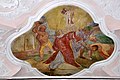 Grafenstein Pfarrkirche Sankt Stefan Deckenfresko Lapidation 11122011 467.jpg 4,288 × 2,848; 1.79 MB
-
 Grafenstein Pfarrkirche Heiliger Stefan 02102007 01.jpg 2,592 × 3,872; 1.47 MB
-
 Grafenstein Pfarrkirche Heiliger Stefan Hauptaltar 08122011 349.jpg 4,288 × 2,848; 2.05 MB
-
 Grafenstein Pfarrkirche Heiliger Stefan Taufkapelle Mater Dolorosa 08122011 349.jpg 2,848 × 4,288; 1.07 MB
-
 Grafenstein Pfarrkirche Heiliger Stefan Taufkapelle Mater Dolorosa 08122011 350.jpg 2,848 × 4,288; 1.56 MB
-
 Grafenstein Pfarrkirche Heiliger Stefan Taufkapelle mit Altar 08122011 347.jpg 2,786 × 4,194; 1.45 MB
-
 Grafenstein Pfarrkirche Sankt Stefan Pietá 11122011 455.jpg 2,848 × 4,288; 1.18 MB
-
 Grafenstein Pfarrkirche Sankt Stefan Sakramentshäuschen 11122011 444.jpg 2,848 × 4,288; 1.51 MB
-
 Grafenstein Schlossweg 1 Schloss und Pfarrkirche 05112011 010.jpg 4,256 × 2,832; 3.44 MB


Categories:
- 12th-century architecture in Carinthia
- Baroque churches in Carinthia
- Churches in Bezirk Klagenfurt Land
- Churches in Dekanat Tainach/Tinje
- Churches in the Roman Catholic Diocese of Gurk
- Cultural heritage monuments in Grafenstein
- Gothic churches in Carinthia
- Grafenstein
- Saint Stephen churches in Carinthia
- Romanesque church towers in Carinthia
- White churches in Carinthia