Category:Pfarrkirche hl. Martin, Grafenschlag
Jump to navigation
Jump to search
| Object location | | View all coordinates using: OpenStreetMap |
|---|
| This category shows the protected monument with the number 31765 in Austria. (Commons, de, Wikidata) |
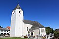
church building in Grafenschlag, Austria  | |||||
| Upload media | |||||
| Instance of | |||||
|---|---|---|---|---|---|
| Named after | |||||
| Patron saint | |||||
| Location | Grafenschlag, Zwettl District, Lower Austria, Austria | ||||
| Heritage designation | |||||
 | |||||
Media in category "Pfarrkirche hl. Martin, Grafenschlag"
The following 6 files are in this category, out of 6 total.
-
 Austria grafenschlag church.jpg 1,200 × 1,600; 728 KB
-
 Hochaltar Pfarrkirche Grafenschlag.jpg 3,168 × 4,752; 7.02 MB
-
 Pfarrkirche Grafenschlag 01.jpg 4,752 × 3,168; 5.27 MB
-
 Pfarrkirche Grafenschlag 02.jpg 3,168 × 4,752; 5.72 MB
-
 Pfarrkirche Grafenschlag Presbyterium von oben.jpg 3,168 × 4,752; 5.28 MB
-
 Presbyterium Pfarrkirche Grafenschlag.jpg 3,168 × 4,752; 5.1 MB


