Category:Pfarrkirche hl. Martin, Behamberg
Jump to navigation
Jump to search
| Object location | | View all coordinates using: OpenStreetMap |
|---|
church building in Lower Austria, Austria  | |||||
| Upload media | |||||
| Instance of | |||||
|---|---|---|---|---|---|
| Named after | |||||
| Location | Behamberg, Amstetten District, Lower Austria, Austria | ||||
| Heritage designation | |||||
 | |||||
Deutsch: Kath. Pfarrkirche hl. Martin, Behamberg
Media in category "Pfarrkirche hl. Martin, Behamberg"
The following 5 files are in this category, out of 5 total.
-
 Behamberg pfarrkirche.JPG 3,104 × 4,672; 4.79 MB
-
 Pfarrkirche Behamberg - Turmansicht.jpg 1,978 × 2,637; 3.88 MB
-
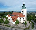 Pfarrkirche Behamberg DJI 0231b.jpg 4,334 × 3,592; 6.67 MB
-
 Pfarrkirche zum hl. Martin in Behamberg.jpg 2,097 × 1,465; 272 KB
-
 Röm.kath. Pfarrkirche Behamberg.jpg 2,560 × 1,920; 521 KB


