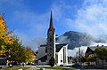
Category:Pfarrkirche hl. Maria, Maishofen
Jump to navigation
Jump to search
| Object location | | View all coordinates using: OpenStreetMap |
|---|
| This category shows the protected monument with the number 42197 in Austria. (Commons, de, Wikidata) |
church building in Maishofen, Austria  | |||||
| Upload media | |||||
| Instance of | |||||
|---|---|---|---|---|---|
| Named after | |||||
| Location | Maishofen, Zell am See District, Salzburg, Austria | ||||
| Street address |
| ||||
| Heritage designation | |||||
 | |||||
Media in category "Pfarrkirche hl. Maria, Maishofen"
The following 18 files are in this category, out of 18 total.
-
 DS-Maishofen-Kirche-1.jpg 2,410 × 2,902; 1,015 KB
-
 DS-Maishofen-Kirche-2.jpg 1,778 × 1,652; 1.03 MB
-
 Kathol. Pfarrkirche Maishofen 01.JPG 2,302 × 3,072; 3.37 MB
-
 Kathol. Pfarrkirche Maishofen 02.JPG 2,966 × 2,266; 3.66 MB
-
 Kathol. Pfarrkirche Maishofen 03.JPG 2,046 × 2,847; 3.13 MB
-
 Kathol. Pfarrkirche Maishofen 04 (retouched).JPG 2,717 × 2,065; 852 KB
-
 Kathol. Pfarrkirche Maishofen 04.JPG 2,717 × 2,065; 2.99 MB
-
 Kathol. Pfarrkirche Maishofen 05.JPG 2,304 × 3,072; 2.73 MB
-
 Kathol. Pfarrkirche Maishofen 06.JPG 2,102 × 2,790; 3.18 MB
-
 Kathol. Pfarrkirche Maishofen 07.JPG 2,595 × 1,886; 2.65 MB
-
 Kathol. Pfarrkirche Maishofen 08.JPG 3,072 × 2,304; 2.76 MB
-
 Katholische Pfarrkirche Maishofen.JPG 5,695 × 3,747; 6.26 MB
-
 Maishofen centrum.jpg 3,264 × 2,448; 2.04 MB
-
 Maishofen kirche.jpg 1,712 × 2,288; 788 KB
-
 Maishofen Kirchturm 1.png 569 × 827; 1.15 MB
-
 Maishofen pfarrkirche.jpg 6,090 × 4,060; 13.43 MB
-
 Maishofen-Relief.jpg 2,023 × 1,387; 575 KB
-
 Maishofen.jpg 3,264 × 2,448; 3.85 MB


.JPG)


