Category:Pfarrkirche hl. Jakobus der Ältere Strassen (Tirol)
Jump to navigation
Jump to search
| Object location | | View all coordinates using: OpenStreetMap |
|---|
church building in Strassen, Austria   | |||||
| Upload media | |||||
| Instance of | |||||
|---|---|---|---|---|---|
| Location | Strassen, Lienz District, Tyrol, Austria | ||||
| Heritage designation | |||||
 | |||||
|
This category shows the remarkable cultural object in the Austrian state of Tyrol listed by the Tyrolean Art Cadastre with the ID
19853. (on tirisMaps, pdf, more images on Commons, Wikidata) |
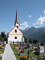
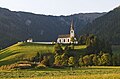
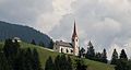
Deutsch: Kath. Pfarrkirche hl. Jakobus der Ältere in Strassen, Osttirol, Österreich.
English: Catholic Church of St. Jakobus der Ältere in Strassen, Tyrol, Austria.
Media in category "Pfarrkirche hl. Jakobus der Ältere Strassen (Tirol)"
The following 21 files are in this category, out of 21 total.
-
 20050901060DR Strassen (Tirol) St Jacob.jpg 2,553 × 1,916; 2.46 MB
-
 20050901065DR Strassen (Tirol) St Jacob.jpg 1,920 × 2,552; 2.5 MB
-
 20050901070DR Strassen (Tirol) St Jacob zum Chor.jpg 1,874 × 2,827; 3.47 MB
-
 20050901075DR Strassen (Tirol) St Jacob im Chor.jpg 1,778 × 2,564; 4.56 MB
-
 20050901080DR Strassen (Tirol) St Jacob Fresken im Chor.jpg 1,796 × 2,988; 3.72 MB
-
 20050901085DR Strassen (Tirol) St Jacob Fresken im Chor.jpg 2,507 × 1,854; 3.24 MB
-
 Kath. Pfarrkirche hl. Jakobus der Ältere 2.JPG 3,456 × 5,184; 10.09 MB
-
 Kath. Pfarrkirche hl. Jakobus der Ältere Alatar.JPG 5,167 × 3,443; 9.55 MB
-
 Kath. Pfarrkirche hl. Jakobus der Ältere Orgel.JPG 5,184 × 3,386; 7.01 MB
-
 Kath. Pfarrkirche hl. Jakobus der Ältere.JPG 5,184 × 3,456; 5.54 MB
-
 Kreuz unweit der Kath. Pfarrkirche hl. Jakobus der Ältere.JPG 3,456 × 5,184; 6.23 MB
-
 Marienstatue Kath. Pfarrkirche hl. Jakobus der Ältere.JPG 5,184 × 3,456; 5.19 MB
-
 Pfarrkirche hl. Jakobus der Ältere Strassen Tirol.jpg 480 × 318; 117 KB
-
 St. Jakobus der Aeltere Strassen-1.jpg 3,500 × 5,341; 2.15 MB
-
 St. Jakobus der Aeltere Strassen-2.jpg 3,514 × 5,334; 1.94 MB
-
 St. Jakobus der Aeltere Strassen-3.jpg 3,544 × 5,224; 1.65 MB
-
 St. Jakobus der Aeltere Strassen-4.jpg 5,225 × 3,580; 1.82 MB
-
 St. Jakobus der Aeltere Strassen-5.jpg 3,504 × 1,881; 717 KB
-
 Strassen - Pfarrkirche hl Jakobus der Ältere - 2.jpg 3,412 × 5,118; 9.2 MB
-
 Strassen - Pfarrkirche hl Jakobus der Ältere.jpg 5,233 × 3,489; 9.42 MB
-

_St_Jacob.jpg)
_St_Jacob.jpg)
_St_Jacob_zum_Chor.jpg)
_St_Jacob_im_Chor.jpg)
_St_Jacob_Fresken_im_Chor.jpg)
_St_Jacob_Fresken_im_Chor.jpg)


