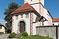
Category:Pfarrkirche St. Peter bei Grafenstein
Jump to navigation
Jump to search
| Object location | | View all coordinates using: OpenStreetMap |
|---|
church building in Grafenstein, Austria  | |||||
| Upload media | |||||
| Instance of | |||||
|---|---|---|---|---|---|
| Location | Grafenstein, Klagenfurt-Land District, Carinthia, Austria | ||||
| Heritage designation | |||||
 | |||||
Media in category "Pfarrkirche St. Peter bei Grafenstein"
The following 20 files are in this category, out of 20 total.
-
 Grafenstein Sankt Peter Pfarrkirche Heilige Petrus und Paulus 17092011 844.jpg 2,848 × 2,049; 1.01 MB
-
 Grafenstein Sankt Peter Pfarrkirche Heilige Petrus und Paulus 22092011 411.jpg 2,848 × 4,288; 1.39 MB
-
 Grafenstein Sankt Peter Pfarrkirche Hll Petrus und Paulus 21092015 7669.jpg 4,118 × 6,189; 13.72 MB
-
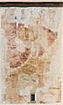 Grafenstein Sankt Peter Pfarrkirche Hll Petrus und Paulus Christophorus 21092015 7672.jpg 3,579 × 5,929; 13.25 MB
-
 Grafenstein Sankt Peter Pfarrkirche Hll Petrus und Paulus Friedhof Kruzifix 21092015 7676.jpg 4,869 × 7,296; 17.62 MB
-
 Grafenstein Sankt Peter Pfarrkirche Hll Petrus und Paulus Friedhofsportal 21092015 7662.jpg 6,757 × 4,788; 17.75 MB
-
 Grafenstein Sankt Peter Pfarrkirche Hll Petrus und Paulus Friedhofsportal 21092015 7665.jpg 4,912 × 7,360; 19.55 MB
-

-

-
 Grafenstein Sankt Peter Pfarrkirche Hll Petrus und Paulus Sakristei 21092015 7673.jpg 7,360 × 4,912; 17.81 MB
-
 Grafenstein Sankt Peter Pfarrkirche Hll Petrus und Paulus Vorhalle 21092015 7661.jpg 7,360 × 4,912; 18.35 MB
-
 Grafenstein Sankt Peter Pfarrkirche Hll Petrus und Paulus West.Portal 21092015 7671.jpg 7,360 × 4,912; 14.3 MB
-
 Grafenstein Sankt Peter Pfarrkirche hll. Petrus und Paulus Detail 21092015 7677.jpg 4,912 × 7,360; 18.23 MB
-

-
 Grafenstein Sankt Peter Pfarrkirche hll. Petrus und Paulus West-Portal 21092015 7670.jpg 4,912 × 7,360; 15.36 MB
-
 Klagenfurt Hoertendorf Pfarrkirche hl Jakobus major Vorhalle 21092015 7668.jpg 7,360 × 4,912; 19.22 MB
-
 Grafenstein Sankt Peter Pfarrhof und Pfarrkirche 12112011 088.jpg 4,288 × 2,848; 1.43 MB
-
 Grafenstein Sankt Peter Pfarrkirche 12112011 089.jpg 4,288 × 2,848; 1.52 MB
-
 Grafenstein Sankt Peter Pfarrkirche Heilige Petrus und Paulus 17092011 833.jpg 2,848 × 4,288; 1.95 MB
-
 Grafenstein Sankt Peter Pfarrkirche Heilige Petrus und Paulus 22092011 415.jpg 4,288 × 2,848; 1.39 MB


