Category:Pfarrkirche Mariä Himmelfahrt, Engelhartszell
Jump to navigation
Jump to search
| Object location | | View all coordinates using: OpenStreetMap |
|---|
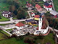
parish church with cemetery in Engelhartszell an der Donau, Austria    | |||||
| Upload media | |||||
| Instance of | |||||
|---|---|---|---|---|---|
| Named after | |||||
| Location | Engelhartszell an der Donau, Schärding District, Upper Austria, Austria | ||||
| Street address |
| ||||
| Heritage designation | |||||
 | |||||
Deutsch: Pfarrkirche "Maria Himmelfahrt" in Engelhartszell an der Donau
Subcategories
This category has only the following subcategory.
I
Media in category "Pfarrkirche Mariä Himmelfahrt, Engelhartszell"
The following 14 files are in this category, out of 14 total.
-
 Engelhartszell - Pfarrkirche 1.jpg 2,560 × 1,920; 3.9 MB
-
 Engelhartszell - Pfarrkirche 2.jpg 3,000 × 4,000; 7.84 MB
-
 Engelhartszell - Pfarrkirche 3 Fenster.jpg 3,000 × 4,000; 4.59 MB
-
 Engelhartszell - Pfarrkirche 3a Fenster.jpg 4,000 × 3,000; 6.44 MB
-
 Engelhartszell - Pfarrkirche 4 Priestergrab.jpg 3,000 × 4,000; 5.04 MB
-
 Engelhartszell - Pfarrkirche 4a Priestergrab.jpg 3,000 × 4,000; 5.02 MB
-
 Engelhartszell - Pfarrkirche 5 Bauinschrift.jpg 3,000 × 4,000; 7.91 MB
-
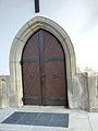 Engelhartszell - Pfarrkirche 6 Portal.jpg 3,000 × 4,000; 5.74 MB
-
 Engelhartszell an der Donau - Pfarrkirche Mariae Himmelfahrt - I.jpg 4,955 × 3,716; 7.06 MB
-
 Engelhartszell an der Donau - Pfarrkirche Mariae Himmelfahrt - II.jpg 3,718 × 5,576; 7.92 MB
-
 Engelhartszell an der Donau - Pfarrkirche Mariae Himmelfahrt.jpg 4,566 × 3,424; 5.6 MB
-
 Engelhartszell Pfarrkirche Friedhof.jpg 5,518 × 3,706; 6 MB
-
 Engelhartszell Pfarrkirche.JPG 2,811 × 2,278; 2.32 MB
-
 Pfarrkirche Mariae Himmelfahrt, Engelhartszell.jpg 4,990 × 3,876; 11.77 MB


