Category:Pfarrkirche Kammersdorf
Jump to navigation
Jump to search
| Object location | | View all coordinates using: OpenStreetMap |
|---|
| This category shows the protected monument with the number 12728 in Austria. (Commons, de, Wikidata) |
church building in Nappersdorf-Kammersdorf, Austria   | |||||
| Upload media | |||||
| Instance of | |||||
|---|---|---|---|---|---|
| Named after | |||||
| Location | Nappersdorf-Kammersdorf, Hollabrunn District, Lower Austria, Austria | ||||
| Heritage designation | |||||
 | |||||
Media in category "Pfarrkirche Kammersdorf"
The following 12 files are in this category, out of 12 total.
-
 Kammersdorf Kirche.jpg 1,922 × 2,831; 3.41 MB
-
 Kammersdorf Pfarrkirche Deckenfresko.jpg 3,648 × 2,736; 3.75 MB
-
 Kammersdorf Pfarrkirche innen.jpg 3,648 × 2,736; 4.06 MB
-
 Kammersdorf Pfarrkirche Orgel.jpg 2,650 × 3,584; 869 KB
-
 Kammersdorf Pfarrkirche.jpg 3,648 × 2,736; 3.7 MB
-
 Kammersdorf Prospekt Detail.jpg 2,448 × 3,264; 1.68 MB
-
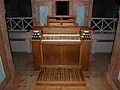 Kammersdorf Spieltisch.jpg 3,264 × 2,448; 1.66 MB
-
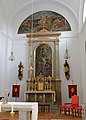 Kirche 12728 Hauptaltar in A-2033 Kammersdorf.jpg 4,000 × 5,583; 2.95 MB
-
 Kirche 12728 in A-2033 Kammersdorf.jpg 3,996 × 5,224; 3.43 MB
-
 Kirche 12728 linker Seitenaltar in A-2033 Kammersdorf.jpg 3,321 × 5,449; 2.18 MB
-
 Kirche 12728 Orgelempore in A-2033 Kammersdorf.jpg 5,340 × 3,646; 2.68 MB
-
 Kirche 12728 rechter Seitenaltar in A-2033 Kammersdorf.jpg 3,310 × 5,207; 2.23 MB


