Category:Pfarrkirche Johannes der Täufer, Schrattenberg
Jump to navigation
Jump to search
| Object location | | View all coordinates using: OpenStreetMap |
|---|
church building in Schrattenberg, Austria   | |||||
| Upload media | |||||
| Instance of | |||||
|---|---|---|---|---|---|
| Location | Schrattenberg, Mistelbach District, Lower Austria, Austria | ||||
| Street address |
| ||||
| Heritage designation | |||||
 | |||||
Media in category "Pfarrkirche Johannes der Täufer, Schrattenberg"
The following 12 files are in this category, out of 12 total.
-
 Kath. Pfarrkirche hl. Johannes der Täufer.jpg 680 × 1,024; 264 KB
-
 Kirche 23398 in A-2172 Schrattenberg.jpg 5,627 × 3,763; 2.5 MB
-
 NOE Schrattenberg Pfarrkirche Johannes d Täufer2.jpg 3,264 × 2,176; 2.34 MB
-
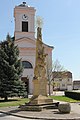
 Pfarrkirche Johannes der Täufer, Dreifaltigkeitssäule, Schrattenberg.jpg 4,576 × 3,064; 3.91 MB
-
 Schrattenberg 4854.jpg 3,888 × 2,592; 654 KB
-
 Schrattenberg-Dreifaltigkeitssäule 5683.JPG 3,456 × 5,184; 5.98 MB
-
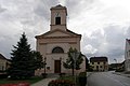
 Schrattenberg-Pfarrkirche 5684.JPG 3,456 × 5,184; 5.92 MB
-
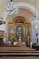
 Schrattenberg-Pfarrkirche 5685.JPG 3,456 × 5,184; 5.07 MB
-
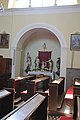
 Schrattenberg-Pfarrkirche 5686.JPG 3,456 × 5,184; 5.73 MB
-
 Schrattenberg-Pfarrkirche 5687.JPG 3,456 × 5,184; 5.73 MB
-
 Schrattenberg-Pfarrkirche 5688.JPG 3,456 × 5,184; 5.03 MB
-
 Schrattenberg-Pfarrkirche 5689.JPG 3,456 × 5,184; 6 MB


