Category:Pfarrkirche Ilz (Steiermark)
Jump to navigation
Jump to search
| Object location | | View all coordinates using: OpenStreetMap |
|---|
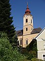
church building in Ilz, Styria, Austria   | |||||
| Upload media | |||||
| Instance of | |||||
|---|---|---|---|---|---|
| Location | Ilz, Hartberg-Fürstenfeld District, Styria, Austria | ||||
| Heritage designation | |||||
 | |||||
Deutsch: Kath. Pfarrkirche hl. Jakobus
Subcategories
This category has the following 2 subcategories, out of 2 total.
I
- Ilz (Pfarrkirche) - Epitaphs (6 F)
Media in category "Pfarrkirche Ilz (Steiermark)"
The following 9 files are in this category, out of 9 total.
-
 Ilz Hauptplatz.JPG 3,428 × 2,334; 5.15 MB
-
 Mariensäule mit Pfarrkirche Ilz.JPG 2,520 × 3,776; 3.27 MB
-
 Pfarrkirche Ilz 1.JPG 2,520 × 3,776; 3.32 MB
-
 Pfarrkirche Ilz 2.JPG 3,220 × 2,502; 6.46 MB
-
 Pfarrkirche Ilz 3.JPG 3,052 × 2,336; 5.34 MB
-
 Pfarrkirche Ilz Steiermark 02.jpg 3,744 × 5,615; 7.78 MB
-
 Pfarrkirche Ilz Steiermark 03.jpg 6,000 × 4,000; 10.95 MB
-
 Pfarrkirche Ilz Steiermark 04.jpg 6,000 × 4,000; 10.21 MB
-
 Pfarrkirche ilz.JPG 1,920 × 2,560; 994 KB


