Category:Pfarrhaus (Rod an der Weil)
Jump to navigation
Jump to search
| Object location | | View all coordinates using: OpenStreetMap |
|---|
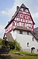
This is the category of the Hessian Kulturdenkmal (cultural monument) with the ID 100732 (Wikidata)
|
| Upload media | |||||
| Location |
| ||||
|---|---|---|---|---|---|
| Heritage designation | |||||
 | |||||
Media in category "Pfarrhaus (Rod an der Weil)"
The following 5 files are in this category, out of 5 total.
-
 Luthmer II-187-Rod an der Weil Pfarrhaus.jpg 1,274 × 1,482; 1.31 MB
-
 Pfarrhaus-Rod-an-der-Weil-A-29-JR-2001-08-21.jpg 2,770 × 4,311; 3.73 MB
-
 Pfarrhof-Rod-an-der-Weil-A-27-JR-2001-08-21.jpg 4,434 × 2,846; 5.83 MB
-
 Rod an der Weil, Kirche und Pfarrhaus.JPG 4,288 × 2,848; 5.58 MB
-
 Rod an der Weil, Pfarrhaus.JPG 2,848 × 4,288; 5.92 MB


