Category:Pfarrhaus, Wynigen
Jump to navigation
Jump to search
| Object location | | View all coordinates using: OpenStreetMap |
|---|
|
This is a category about a cultural property of national significance in Switzerland with KGS number 01360
|
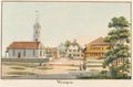
church residential building in Wynigen in the canton of Bern, Switzerland  | |||||
| Upload media | |||||
| Instance of | |||||
|---|---|---|---|---|---|
| Part of | |||||
| Location | Wynigen, Emmental administrative district, Emmental-Oberaargau administrative region, Bern, Switzerland | ||||
| Street address |
| ||||
| Heritage designation | |||||
| Inception |
| ||||
 | |||||
Media in category "Pfarrhaus, Wynigen"
The following 3 files are in this category, out of 3 total.
-
 CH-NB - Wynigen - Collection Gugelmann - GS-GUGE-WEIBEL-D-158a.tif 5,783 × 3,646, 2 pages; 43.87 MB
-
 CH-NB - Wynigen - Collection Gugelmann - GS-GUGE-WEIBEL-D-158b.tif 6,082 × 3,998, 2 pages; 52.53 MB
-
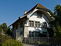 Wynigen Pfarrhaus1.jpg 4,016 × 3,012; 1.86 MB