Category:Perris maps of Brooklyn warehouses published in 1860
Jump to navigation
Jump to search
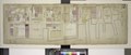
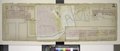
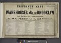
Maps from: Perris, Wm. Insurance Maps of the Warehouses, &c. in Brooklyn From the Navy Yard to Partition Street. (New York: Perris & Browne, ©1860). (Corrected to 1861 by Henry H. Browne.) Comprising title page with index, plus 11 maps (plates) numbered 1–6 and 8–12 (the library has no No. 7); the title page and Nos. 9, 11, and 12 are single-page plates and the rest are double-page plates.
Online at The New York Public Library Digital Collections website, Insurance maps of the warehouses…
Media in category "Perris maps of Brooklyn warehouses published in 1860"
The following 12 files are in this category, out of 12 total.