Category:Perris & Browne maps of Manhattan published in 1859 (V. 5–6)
Jump to navigation
Jump to search
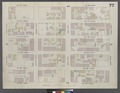
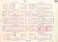
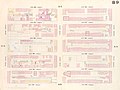
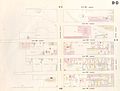
Maps from: Perris, William. Maps of the City of New-York (New York: Perris & Browne) in seven volumes, each composed of section maps and title page with volume index (all double-page plates except Plate 66½).
- Volume 5 (1859), 17 section maps (Plate 67–83).
- Volume 6 (1859), 18 section maps (Plate 84–101).
This category includes TIF versions of both volume keys and Plates 70, 71, 74, 75, and 77–80.
Source: The New York Public Library Digital Collections website, Maps of the city of New York [1857–1862].
Media in category "Perris & Browne maps of Manhattan published in 1859 (V. 5–6)"
The following 50 files are in this category, out of 50 total.
-
 Volume 5 Index Map.) NYPL1268413.tiff 6,299 × 4,880; 87.96 MB
-
 Volume 6 Index Map.) NYPL1268414.tiff 6,299 × 4,880; 87.96 MB
-
 Perris Manhattan V. 5 title page and volume key publ. 1859.jpg 5,964 × 4,462; 7.06 MB
-
 Perris Manhattan V. 6 title page and volume key publ. 1859.jpg 5,756 × 4,119; 4.81 MB
-
 Madison Square 1857 real estate map.jpg 6,085 × 4,582; 15.21 MB
-
 Perris Manhattan V. 5 Plate 067 publ. 1859.jpg 5,627 × 4,013; 3.61 MB
-
 Perris Manhattan V. 5 Plate 068 publ. 1859.jpg 5,783 × 4,476; 4.7 MB
-
 Perris Manhattan V. 5 Plate 069 publ. 1859.jpg 6,044 × 4,251; 4.49 MB
-
 Perris Manhattan V. 5 Plate 070 publ. 1859.jpg 5,562 × 4,471; 4.81 MB
-
 Perris Manhattan V. 5 Plate 070 publ. 1859.tif 6,299 × 4,880; 87.97 MB
-
 Perris Manhattan V. 5 Plate 071 publ. 1859.jpg 5,830 × 4,453; 5.59 MB
-
 Perris Manhattan V. 5 Plate 071 publ. 1859.tif 6,299 × 4,880; 87.97 MB
-
 Perris Manhattan V. 5 Plate 072 publ. 1859.jpg 6,012 × 4,269; 4.39 MB
-
 Perris Manhattan V. 5 Plate 073 publ. 1859.jpg 5,376 × 3,931; 3.11 MB
-
 Perris Manhattan V. 5 Plate 074 publ. 1859.jpg 5,799 × 4,471; 5.31 MB
-
 Perris Manhattan V. 5 Plate 074 publ. 1859.tif 6,299 × 4,880; 87.97 MB
-
 Perris Manhattan V. 5 Plate 075 publ. 1859.jpg 6,021 × 4,216; 5.06 MB
-
 Perris Manhattan V. 5 Plate 075 publ. 1859.tif 6,299 × 4,880; 87.97 MB
-
 Perris Manhattan V. 5 Plate 076 publ. 1859.jpg 5,290 × 4,216; 2.97 MB
-
 Perris Manhattan V. 5 Plate 077 publ. 1859.jpg 5,855 × 4,457; 5.34 MB
-
 Perris Manhattan V. 5 Plate 077 publ. 1859.tif 6,299 × 4,880; 87.97 MB
-
 Perris Manhattan V. 5 Plate 078 publ. 1859.jpg 5,950 × 4,174; 4.73 MB
-
 Perris Manhattan V. 5 Plate 078 publ. 1859.tif 6,299 × 4,880; 87.97 MB
-
 Perris Manhattan V. 5 Plate 079 publ. 1859.jpeg 6,299 × 4,880; 2.92 MB
-
 Perris Manhattan V. 5 Plate 079 publ. 1859.jpg 4,617 × 4,356; 3.55 MB
-
 Perris Manhattan V. 5 Plate 079 publ. 1859.tif 6,299 × 4,880; 48.7 MB
-
 Perris Manhattan V. 5 Plate 080 publ. 1859.jpg 5,912 × 4,435; 4.61 MB
-
 Perris Manhattan V. 5 Plate 080 publ. 1859.tif 6,299 × 4,880; 87.96 MB
-
 Perris Manhattan V. 5 Plate 81 (small) publ. 1859.jpg 2,429 × 1,798; 694 KB
-
 Perris Manhattan V. 5 Plate 081 publ. 1859.jpg 5,972 × 4,415; 4.16 MB
-
 Perris Manhattan V. 5 Plate 082 publ. 1859.jpg 5,069 × 4,391; 2.95 MB
-
 Perris Manhattan V. 5 Plate 083 publ. 1859.jpg 5,507 × 4,433; 3.82 MB
-
 Perris Manhattan V. 6 Plate 084 publ. 1859.jpg 5,920 × 4,369; 3.35 MB
-
 Perris Manhattan V. 6 Plate 085 publ. 1859.jpg 5,984 × 4,328; 4.48 MB
-
 Perris Manhattan V. 6 Plate 086 publ. 1859.jpg 5,818 × 4,348; 4.38 MB
-
 Perris Manhattan V. 6 Plate 087 publ. 1859.jpg 5,405 × 4,366; 3.45 MB
-
 Perris Manhattan V. 6 Plate 088 publ. 1859.jpg 5,830 × 4,279; 4.59 MB
-
 Perris Manhattan V. 6 Plate 089 publ. 1859.jpg 5,744 × 4,324; 4.03 MB
-
 Perris Manhattan V. 6 Plate 090 publ. 1859.jpg 5,610 × 4,268; 3.38 MB
-
 Perris Manhattan V. 6 Plate 091 publ. 1859.jpg 5,751 × 4,361; 4.56 MB
-
 Perris Manhattan V. 6 Plate 092 publ. 1859.jpg 5,821 × 4,394; 4.27 MB
-
 Perris Manhattan V. 6 Plate 093 publ. 1859.jpg 5,864 × 4,239; 3.08 MB
-
 Perris Manhattan V. 6 Plate 094 publ. 1859.jpg 5,848 × 4,327; 4.18 MB
-
 Perris Manhattan V. 6 Plate 095 publ. 1859.jpg 5,609 × 4,257; 4.09 MB
-
 Perris Manhattan V. 6 Plate 096 publ. 1859.jpg 5,886 × 4,353; 3.99 MB
-
 Perris Manhattan V. 6 Plate 097 publ. 1859.jpg 5,936 × 4,400; 4.23 MB
-
 Perris Manhattan V. 6 Plate 098 publ. 1859.jpg 5,772 × 4,473; 4.07 MB
-
 Perris Manhattan V. 6 Plate 099 publ. 1859.jpg 5,964 × 4,441; 3.82 MB
-
 Perris Manhattan V. 6 Plate 100 publ. 1859.jpg 5,948 × 4,307; 3.95 MB
-
 Perris Manhattan V. 6 Plate 101 publ. 1859.jpg 5,899 × 4,290; 3.85 MB


_publ._1859.jpg)


