Category:Parkfriedhof Ferlach
Jump to navigation
Jump to search
| This category shows the protected monument with the number 61672 in Austria. (Commons, de, Wikidata) |
| Object location | | View all coordinates using: OpenStreetMap |
|---|
cemetery in Ferlach, Austria  | |||||
| Upload media | |||||
| Instance of | |||||
|---|---|---|---|---|---|
| Location | Ferlach, Klagenfurt-Land District, Carinthia, Austria | ||||
| Street address |
| ||||
| Heritage designation | |||||
 | |||||
Media in category "Parkfriedhof Ferlach"
The following 35 files are in this category, out of 35 total.
-
 Ferlach Parkfriedhof Aufbahrungshalle mit Relief 28012017 6206.jpg 7,360 × 4,647; 18.52 MB
-
 Ferlach Parkfriedhof Aufbahrungshalle Relief von Franz Schneeweiß 16092023 3984.jpg 7,107 × 4,753; 27.18 MB
-
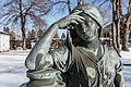
 Ferlach Parkfriedhof Aufbahrungshalle und Skulptur Die Trauernde 16092023 3979.jpg 7,360 × 4,912; 22.07 MB
-
 Ferlach Parkfriedhof Aufbahrungshalle und Skulptur Die Trauernde 17052011 741.jpg 4,288 × 2,848; 3.92 MB
-
 Ferlach Parkfriedhof Aufbahrungshalle und Skulptur Die Trauernde 28012017 6217.jpg 7,159 × 4,778; 16.72 MB
-
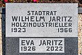
 Ferlach Parkfriedhof Grabstaette Wilhelm Jaritz 28012017 6211.jpg 4,851 × 7,268; 22.91 MB
-
 Ferlach Parkfriedhof Grabstätte Familie Jaritz 16092023 3969.jpg 7,360 × 4,912; 35.44 MB
-
 Ferlach Parkfriedhof Grabstätte Familie Jaritz 16092023 3973.jpg 6,427 × 4,912; 33.63 MB
-
 Ferlach Parkfriedhof Grabstätte Familie Jaritz 16092023 3974.jpg 7,360 × 4,912; 30.32 MB
-
 Ferlach Parkfriedhof Grabstätte Familie Jaritz Grabplatte 16092023 3971.jpg 7,360 × 4,912; 29.71 MB
-
 Ferlach Parkfriedhof Grabstätte Familie Jaritz Grabplatte 28012017 6210.jpg 6,268 × 4,131; 23.69 MB
-
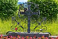 Ferlach Parkfriedhof Grabstätte Familie Jaritz Schmiedeeisenkreuz 16092023 3972.jpg 7,288 × 4,833; 31.99 MB
-
 Ferlach Parkfriedhof Grabstätte Familie Kometter-Frank 16092023 3966.jpg 4,912 × 7,360; 26.87 MB
-
 Ferlach Parkfriedhof Grabstätte Wilhelm Jaritz 28012017 6209.jpg 7,360 × 4,912; 24.02 MB
-
 Ferlach Parkfriedhof Grabstätten Blick gen Košuta 16092023 3964.jpg 7,360 × 4,912; 29.16 MB
-
 Ferlach Parkfriedhof Grabstätten Blick gen Košuta 16092023 3965.jpg 7,360 × 4,912; 28.33 MB
-
 Ferlach Parkfriedhof Grabstätten Blick gen Matzen 16092023 3976.jpg 7,154 × 4,775; 24.86 MB
-
 Ferlach Parkfriedhof Graeber mit Singerberg im Hintergrund 28012017 6213.jpg 7,360 × 4,912; 19.25 MB
-
 Ferlach Parkfriedhof Holzkreuz 28012017 6216.jpg 4,912 × 7,360; 22.04 MB
-
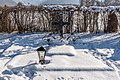
 Ferlach Parkfriedhof Kriegerdenkmal 16092023 3977.jpg 7,360 × 4,912; 30.7 MB
-
 Ferlach Parkfriedhof Kriegerdenkmal 16092023 3978.jpg 7,360 × 4,912; 32.5 MB
-
 Ferlach Parkfriedhof Kriegerdenkmal 17052011 742.jpg 4,288 × 2,848; 3.88 MB
-
 Ferlach Parkfriedhof Kriegerdenkmal 28012017 6207.jpg 7,360 × 4,912; 28.05 MB
-
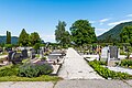 Ferlach Parkfriedhof Nord-Teil 16092023 3963.jpg 7,360 × 4,912; 28.36 MB
-
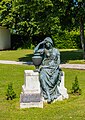
 Ferlach Parkfriedhof Skulptur Die Trauernde 16092023 3980.jpg 7,360 × 4,912; 28.06 MB
-
 Ferlach Parkfriedhof Skulptur Die Trauernde 16092023 3982.jpg 4,496 × 6,875; 23.32 MB
-
 Ferlach Parkfriedhof Skulptur Die Trauernde 16092023 3983.jpg 7,190 × 4,912; 19.1 MB
-
 Ferlach Parkfriedhof Skulptur Die Trauernde 16092023 3985.jpg 4,912 × 6,922; 26.17 MB
-
 Ferlach Parkfriedhof Skulptur Die Trauernde 17052011 744.jpg 2,848 × 4,288; 3.62 MB
-
 Ferlach Parkfriedhof Skulptur Die Trauernde 28012017 6205.jpg 4,439 × 6,651; 11.15 MB
-
 Ferlach Parkfriedhof Skulptur Die Trauernde 28012017 6218.jpg 4,182 × 6,338; 11.96 MB
-
 Ferlach Parkfriedhof Skulptur Die Trauernde 28012017 6220.jpg 7,360 × 4,912; 14.39 MB
-
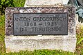 Ferlach Parkfriedhof Skulptur Die Trauernde Gedenktafel 16092023 3981.jpg 7,226 × 4,823; 28.21 MB
-
 Ferlach Parkfriedhof SO-Teil 16092023 3975.jpg 7,360 × 4,912; 29.12 MB
-
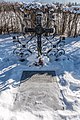
 Ferlach Parkfriedhof Zentrum Eisenkreuz 16092023 3968.jpg 7,360 × 4,912; 28.58 MB


