Category:Parish church, Reingers
Jump to navigation
Jump to search
| Object location | | View all coordinates using: OpenStreetMap |
|---|
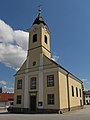
| This category shows the protected monument with the number 26264 in Austria. (Commons, de, Wikidata) |
church building in Reingers, Austria  | |||||
| Upload media | |||||
| Instance of | |||||
|---|---|---|---|---|---|
| Named after | |||||
| Location | Reingers, Gmünd District, Lower Austria, Austria | ||||
| Heritage designation | |||||
 | |||||
Subcategories
This category has only the following subcategory.
Media in category "Parish church, Reingers"
The following 9 files are in this category, out of 9 total.
-
 2016-09-29 GuentherZ (17) Reingers Kirche Altar.jpg 6,000 × 4,000; 11.21 MB
-
 Kath. Pfarrkirche Hl. Dreifaltigkeit in Reingers.jpg 2,736 × 3,648; 1.5 MB
-
 Reingers 2273.JPG 3,456 × 5,184; 4.75 MB
-
 Reingers 2274.JPG 3,456 × 5,184; 5.18 MB
-
 Reingers 2277.JPG 3,456 × 5,184; 5.33 MB
-
 Reingers 2292.JPG 5,184 × 3,456; 4.73 MB
-
 Reingers 2304.JPG 3,456 × 5,184; 4.17 MB
-
 Reingers 2307.JPG 3,456 × 5,184; 4.24 MB
-
 Reingers 2309.JPG 3,456 × 5,184; 5.66 MB
_Reingers_Kirche_Altar.jpg)


