Category:Pampus (isle)
Jump to navigation
Jump to search
 | |||||
| Upload media | |||||
| Instance of | |||||
|---|---|---|---|---|---|
| Location | Muiderberg, Gooise Meren, North Holland, Netherlands | ||||
| Street address |
| ||||
| Heritage designation |
| ||||
 | |||||
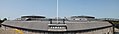
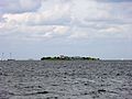
English: Pampus is an artificial island and fort located in the IJ Bay near Amsterdam. It was completed in 1895 as part of the Defence Line of Amsterdam (Dutch: Stelling van Amsterdam). In 1996 it was designated a UNESCO World Heritage Site as part of the Defence Line.
Nederlands: Het Pampus is een kunstmatig eiland en fort, onderdeel van de Stelling van Amsterdam. Pampus is gelegen voor de monding van het IJ in de voormalige Zuiderzee ten oosten van Amsterdam en ten noorden van Muiden.
|
This is a category about rijksmonument number 526452
|
| Address |
|
Subcategories
This category has only the following subcategory.
A
- Aerial photographs of Pampus (16 F)
Media in category "Pampus (isle)"
The following 71 files are in this category, out of 71 total.
-

-
Amsterdamse studenten bezetten Pampus Weeknummer 62-29 - Open Beelden - 43706.ogv 1 min 24 s, 384 × 288; 11.16 MB
-
 Droge gracht met beer - Muiden - 20339096 - RCE.jpg 1,187 × 1,200; 281 KB
-
 Droge gracht met beer - Muiden - 20341756 - RCE.jpg 1,191 × 1,200; 238 KB
-
 Droge gracht met beer - Muiden - 20341757 - RCE.jpg 1,190 × 1,200; 320 KB
-
 Eiland Pampus binnen.JPG 2,272 × 1,704; 947 KB
-
 Fort Pampus (2).jpg 2,048 × 1,536; 710 KB
-
 Fort Pampus 3.jpg 1,697 × 1,502; 572 KB
-
 Fort Pampus 4.jpg 1,491 × 1,536; 767 KB
-
 Fort Pampus 5.jpg 1,743 × 1,529; 950 KB
-
 Fort Pampus doorsnede A-B.jpg 2,892 × 2,003; 584 KB
-
 Fort Pampus doorsneden bouwtekening.jpg 2,900 × 1,903; 933 KB
-
 Fort Pampus een kachel.JPG 1,728 × 2,304; 672 KB
-
 Fort Pampus het huis van de fortwachter.JPG 2,304 × 1,728; 1.42 MB
-
 Fort Pampus ingang tot buitenring fort.JPG 2,304 × 1,728; 1.42 MB
-
 Fort Pampus plattegrond begane grond.jpg 2,720 × 1,963; 1.1 MB
-
 Fort Pampus plattegrond met renvooi.jpg 2,764 × 2,127; 946 KB
-
 Fort Pampus Sleutelgang.JPG 1,728 × 2,304; 804 KB
-
 Fort Pampus WC in de binnenring.JPG 2,304 × 1,728; 1.42 MB
-
 Fort Pampus.jpg 2,048 × 1,536; 717 KB
-
 Gang - Muiden - 20339097 - RCE.jpg 1,190 × 1,200; 252 KB
-
 Gustaaf Oosterhuis, Afb ANWQ00435000001.jpg 5,427 × 3,966; 1.88 MB
-
 Gustaaf Oosterhuis, Afb ANWQ00436000001.jpg 5,428 × 3,960; 1.74 MB
-
 Gustaaf Oosterhuis, Afb ANWQ00437000001.jpg 5,438 × 3,946; 1.79 MB
-
 Gustaaf Oosterhuis, Afb ANWQ00438000001.jpg 5,313 × 3,975; 1.17 MB
-
 Gustaaf Oosterhuis, Afb ANWQ00439000001.jpg 5,306 × 3,966; 1.29 MB
-
 Gustaaf Oosterhuis, Afb ANWQ00440000001.jpg 5,305 × 3,986; 1.32 MB
-
 Gustaaf Oosterhuis, Afb ANWQ00441000001.jpg 5,305 × 3,986; 1.39 MB
-
 Gustaaf Oosterhuis, Afb ANWQ00442000001.jpg 5,308 × 3,973; 1.33 MB
-
 Gustaaf Oosterhuis, Afb ANWQ00443000001.jpg 5,296 × 3,989; 1.16 MB
-
 HaventjePampus2011.JPG 3,519 × 2,307; 1.7 MB
-
 IngangPampus2011.JPG 2,592 × 3,872; 2.87 MB
-
 Interieur, verbindingsgang - Muiden - 20341760 - RCE.jpg 1,186 × 1,200; 183 KB
-
 Interieur, verblijf van de manschappen - Muiden - 20341759 - RCE.jpg 1,186 × 1,200; 281 KB
-
 Interieur, waterkelder - Muiden - 20341761 - RCE.jpg 1,194 × 1,200; 213 KB
-
 Koepelschacht - Muiden - 20339095 - RCE.jpg 1,187 × 1,200; 312 KB
-
 Koepelschacht - Muiden - 20341758 - RCE.jpg 1,194 × 1,200; 256 KB
-
 Koepelschacht - Muiden - 20341762 - RCE.jpg 1,191 × 1,200; 279 KB
-
 Locatie waar vroeger het kanon zich bevond.JPG 2,304 × 1,728; 337 KB
-
Nl-pampus.ogg 1.1 s; 15 KB
-
 Pampus (33067731998).jpg 4,860 × 2,571; 3.79 MB
-
 Pampus 2018 1.jpg 4,928 × 3,264; 8.94 MB
-
 Pampus 2018 10.jpg 4,928 × 3,264; 7.68 MB
-
 Pampus 2018 11.jpg 4,928 × 3,264; 6.78 MB
-
 Pampus 2018 12.jpg 4,928 × 3,264; 6.52 MB
-
 Pampus 2018 13.jpg 4,928 × 3,264; 6.34 MB
-
 Pampus 2018 14.jpg 4,928 × 3,264; 6.84 MB
-
 Pampus 2018 15.jpg 4,928 × 3,264; 5.34 MB
-
 Pampus 2018 2.jpg 4,928 × 3,264; 6.54 MB
-
 Pampus 2018 3.jpg 4,928 × 3,264; 7.95 MB
-
 Pampus 2018 4.jpg 3,264 × 4,928; 9.18 MB
-
 Pampus 2018 5.jpg 4,928 × 3,264; 9.96 MB
-
 Pampus 2018 6.jpg 3,264 × 4,928; 9.39 MB
-
 Pampus 2018 7.jpg 4,928 × 3,264; 8.86 MB
-
 Pampus 2018 8.jpg 4,928 × 3,264; 5.31 MB
-
 Pampus 2018 9.jpg 4,928 × 3,264; 7.08 MB
-
 Pampus 2019.jpg 3,183 × 1,889; 746 KB
-
 Pampus armourplates.jpg 554 × 428; 38 KB
-
 Pampus haven.png 800 × 509; 576 KB
-
 Pampus renovatie Genie 103 Constructiecompagnie 02.jpg 6,838 × 4,559; 2.87 MB
-
 Pampus renovatie Genie 103 Constructiecompagnie 03.jpg 1,250 × 833; 189 KB
-
 Pampus-aanzicht.jpg 3,264 × 2,448; 2.55 MB
-
 Pampus-haven.jpg 400 × 300; 112 KB
-
 Panorama of the fort on Pampus.jpg 7,510 × 2,142; 2.22 MB
-
 PlattegrondPampus2011.JPG 3,872 × 2,592; 3.37 MB
-
 Stedenbouwkundige studie Pampus (14204699949).jpg 2,000 × 976; 1.52 MB
-
 Uitbreiding Pampus - Pampus expansion plan (9771912233).jpg 1,200 × 772; 774 KB
-
 Uitbreidingsplan Pampus - Pampus Expansion Plan (6143543120).jpg 1,200 × 1,187; 479 KB
-
 Vanaf het IJsselmeer - Muiden - 20341754 - RCE.jpg 1,188 × 1,200; 228 KB
-
 Vanaf het IJsselmeer - Muiden - 20341755 - RCE.jpg 1,198 × 1,200; 230 KB
-
 Zicht op Pampus.jpg 3,539 × 2,654; 487 KB
.jpg)


.jpg)


.jpg)


.jpg)
.jpg)
.jpg)


