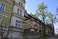
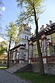
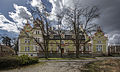
Category:Palace in Kłonice
Jump to navigation
Jump to search
| Object location | | View all coordinates using: OpenStreetMap |
|---|
Polski: Kłonice - zespół pałacowy, XVI, XIX:
_ID_591446.jpg) | |||||
| Upload media | |||||
| Instance of | |||||
|---|---|---|---|---|---|
| Location | Kłonice, Gmina Paszowice, Jawor County, Lower Silesian Voivodeship, Poland | ||||
| Heritage designation |
| ||||
 | |||||
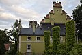
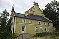
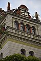
- - pałac, XVI, XIX;
- - park;
- - folwark:
- - stajnia z wozownią;
- - obora;
- - chlewnia;
- - spichrz;
- - oficyna mieszkalna.
Media in category "Palace in Kłonice"
The following 21 files are in this category, out of 21 total.
-
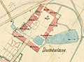 Ausschnitt-Lageplan-Schloss Klonitz.jpg 888 × 649; 302 KB
-
 Kłonice (0001).jpg 6,000 × 4,000; 7.91 MB
-
 Kłonice (0003).jpg 6,000 × 4,000; 8.84 MB
-
 Kłonice (0004).jpg 6,000 × 4,000; 6.41 MB
-
 Kłonice (0005).jpg 4,000 × 6,000; 7.58 MB
-
 Kłonice (0007).jpg 4,000 × 6,000; 8.2 MB
-
 Kłonice (0008).jpg 6,000 × 4,000; 7.97 MB
-
 Kłonice (0012).jpg 6,000 × 4,000; 7.71 MB
-
 Kłonice (004).jpg 4,416 × 3,312; 5.32 MB
-
 Kłonice Folwark.JPG 4,320 × 3,240; 1.12 MB
-
 Kłonice Pałac.JPG 4,320 × 3,240; 1.74 MB
-
 Kłonice Zespół Pałacowy.JPG 4,320 × 3,240; 930 KB
-
 Pałac Kłonice01.jpg 4,288 × 2,848; 4.02 MB
-
 Pałac Kłonice02.jpg 4,288 × 2,848; 4.22 MB
-
 Pałac Kłonice03.jpg 2,848 × 4,288; 3.06 MB
-
 Pałac Kłonice04.jpg 4,288 × 2,848; 4.05 MB
-
 Pałac Kłonice05.jpg 4,288 × 2,848; 4.16 MB
-
 Pałac Kłonice06.jpg 2,848 × 4,288; 4.72 MB
-
 SM Kłonice - pałac (1) ID 591446.jpg 4,255 × 2,553; 8.47 MB
-
 SM Kłonice - pałac (5) ID 591446.jpg 3,749 × 2,499; 7.35 MB
-
 SM Kłonice14 - oficyna pałacu (0) ID 591453.jpg 4,851 × 3,234; 12.25 MB

.jpg)
.jpg)
.jpg)
.jpg)
.jpg)
.jpg)
.jpg)
.jpg)


_ID_591446.jpg)
_ID_591453.jpg)