Category:Pakhuis De Vlijt (Coevorden)
Jump to navigation
Jump to search
| Object location | | View all coordinates using: OpenStreetMap |
|---|
 | |||||
| Upload media | |||||
| Instance of | |||||
|---|---|---|---|---|---|
| Part of | |||||
| Location | Coevorden, Drenthe, Netherlands | ||||
| Heritage designation |
| ||||
 | |||||
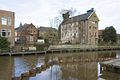
Nederlands: Pakhuis De Vlijt
|
This is a category about rijksmonumentcomplex number 468599
|
|
This is a category about rijksmonument number 468602
|
| Address |
|
Media in category "Pakhuis De Vlijt (Coevorden)"
The following 9 files are in this category, out of 9 total.
-
 Coevorden Haven.JPG 3,968 × 2,976; 2.5 MB
-
 Coevorden Kasteel 6 Pakuis De Vlijt.jpg 3,000 × 4,000; 1.33 MB
-
 Coevorden, Netherlands - panoramio (3).jpg 2,048 × 1,148; 618 KB
-
 Coevorden, Netherlands - panoramio (8).jpg 2,048 × 1,148; 630 KB
-
 Coevorden, Netherlands - panoramio (9).jpg 2,048 × 1,148; 623 KB
-

-
 Overzicht van het aan het water gelegen pakhuis - Coevorden - 20410125 - RCE.jpg 1,200 × 797; 226 KB
-
-


.jpg)
.jpg)
.jpg)


