Category:Oude Vest 9, Breda
Jump to navigation
Jump to search
| Object location | | View all coordinates using: OpenStreetMap |
|---|
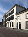
house in Breda, Netherlands  | |||||
| Upload media | |||||
| Instance of | |||||
|---|---|---|---|---|---|
| Location | Breda, North Brabant, Netherlands | ||||
| Street address |
| ||||
| Located on street | |||||
| Heritage designation |
| ||||
 | |||||
|
This is a category about rijksmonument number 10268
|
| Address |
|
Media in category "Oude Vest 9, Breda"
The following 16 files are in this category, out of 16 total.
-
 Breda Oude Vest9.jpg 2,736 × 3,648; 5.23 MB
-
 Detail Oude Vest 9, Breda DSCF1971.jpg 1,536 × 2,048; 1.47 MB
-
 Detail Teun Hocks P1370770.jpg 4,000 × 2,672; 5 MB
-
 Oude Vest 9, Breda DSCF1970.jpg 2,048 × 1,536; 1.48 MB
-
 Oude Vest 9, Breda DSCF1972.jpg 2,048 × 1,536; 1.46 MB
-
 Oude Vest 9, Breda P1370771.jpg 4,000 × 2,672; 5.12 MB
-
 Oude Vest 9, Breda P1370772.jpg 4,000 × 2,672; 5.08 MB
-
 Oude Vest 9, Breda P1370773.jpg 4,000 × 2,672; 5.1 MB
-
 Oude Vest 9, Breda P1370774.jpg 4,000 × 2,672; 4.23 MB
-
 Voorgevel - Breda - 20041435 - RCE.jpg 839 × 1,200; 197 KB
-
 Weeshuis aan de Oude Vest - Breda - 20040715 - RCE.jpg 958 × 1,200; 216 KB
-
 Weeshuis aan de Oude Vest - Breda - 20040716 - RCE.jpg 958 × 1,200; 210 KB
-
 Weeshuis aan de Oude Vest - Breda - 20040717 - RCE.jpg 1,200 × 955; 241 KB
-
 Weeshuis aan de Oude Vest - Breda - 20040718 - RCE.jpg 961 × 1,200; 260 KB
-
 Weeshuis aan de Oude Vest - Breda - 20040719 - RCE.jpg 958 × 1,200; 285 KB
-
 Weeshuis aan de Oude Vest - Breda - 20040720 - RCE.jpg 1,200 × 952; 231 KB


