Category:Oude Raadhuis Tongelre (Eindhoven)
Jump to navigation
Jump to search
| Object location | | View all coordinates using: OpenStreetMap |
|---|
 | |||||
| Upload media | |||||
| Instance of | |||||
|---|---|---|---|---|---|
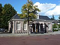
| Location | Tongelre, North Brabant, Netherlands | ||||
| Street address |
| ||||
| Architect | |||||
| Heritage designation |
| ||||
 | |||||
|
This is a category about rijksmonument number 518802
|
| Address |
|
Media in category "Oude Raadhuis Tongelre (Eindhoven)"
The following 6 files are in this category, out of 6 total.
-
 Linkerzijgevel - Tongelre - 20209752 - RCE.jpg 1,190 × 1,200; 368 KB
-
 Oude raadhuis Tongelre.jpg 933 × 685; 115 KB
-
 Schetsontwerp raadhuis Tongelre.jpg 2,096 × 1,700; 376 KB
-
 Tegeltableau raadhuis Tongelre.png 2,244 × 1,152; 4.27 MB
-
 Voor en rechterzijgevel - Tongelre - 20209751 - RCE.jpg 1,185 × 1,200; 296 KB
-
 Wijkcentrum 't Oude Raadhuis Tongelre Eindhoven.JPG 4,320 × 3,240; 5.72 MB


