Category:Othelloplate
Jump to navigation
Jump to search
| Object location | | View all coordinates using: OpenStreetMap |
|---|
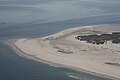
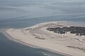
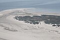
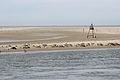
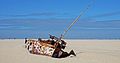
Deutsch: Die Othelloplate ist eine Sandbank und gleichzeitig das östliche Ende der Ostfriesischen Insel Norderney.
English: The Othelloplate is a sandbank and also the eastern end of the East Frisian island Norderney.
Sandbank  | |||||
| Upload media | |||||
| Instance of | |||||
|---|---|---|---|---|---|
| Part of | |||||
| Location | North Sea | ||||
| Population |
| ||||
 | |||||
Media in category "Othelloplate"
The following 36 files are in this category, out of 36 total.
-
 Flug Norderney 2010 PD 138.JPG 4,272 × 2,848; 3.45 MB
-
 Flug Norderney 2010 PD 139.JPG 4,272 × 2,848; 3.39 MB
-
 Flug Norderney 2010 PD 140.JPG 4,272 × 2,848; 3.47 MB
-
 Flug Norderney 2010 PD 141.JPG 4,272 × 2,848; 3.45 MB
-
 Flug Norderney 2010 PD 142.JPG 4,272 × 2,848; 3.39 MB
-
 Flug Norderney 2010 PD 161.JPG 4,272 × 2,848; 3.57 MB
-
 Flug Norderney 2010 PD 162.JPG 4,272 × 2,848; 3.63 MB
-
 Flug Norderney 2010 PD 163.JPG 4,272 × 2,848; 3.11 MB
-
 Grey Seal Norderney.jpg 3,245 × 2,163; 1.9 MB
-
 Kegelrobben und Seehundkolonie.JPG 5,184 × 3,456; 2.39 MB
-
 Kegelrobben und Seehundkolonie2.JPG 5,184 × 3,456; 3.38 MB
-
 Nationalpark Niedersächsisches Wattenmeer - Norderney - Das Wrack am Ostende (1).jpg 2,268 × 1,512; 3.04 MB
-
 Nationalpark Niedersächsisches Wattenmeer - Norderney - Das Wrack am Ostende (10).jpg 2,268 × 1,512; 2.88 MB
-
 Nationalpark Niedersächsisches Wattenmeer - Norderney - Das Wrack am Ostende (11).jpg 2,268 × 1,512; 4.04 MB
-
 Nationalpark Niedersächsisches Wattenmeer - Norderney - Das Wrack am Ostende (2).jpg 2,268 × 1,512; 2.75 MB
-
 Nationalpark Niedersächsisches Wattenmeer - Norderney - Das Wrack am Ostende (3).jpg 2,268 × 1,512; 2.46 MB
-
 Nationalpark Niedersächsisches Wattenmeer - Norderney - Das Wrack am Ostende (4).jpg 2,268 × 1,512; 2.88 MB
-
 Nationalpark Niedersächsisches Wattenmeer - Norderney - Das Wrack am Ostende (5).jpg 2,268 × 1,512; 2.51 MB
-
 Nationalpark Niedersächsisches Wattenmeer - Norderney - Das Wrack am Ostende (6).jpg 2,268 × 1,512; 2.38 MB
-
 Nationalpark Niedersächsisches Wattenmeer - Norderney - Das Wrack am Ostende (7).jpg 2,268 × 1,512; 2.58 MB
-
 Nationalpark Niedersächsisches Wattenmeer - Norderney - Das Wrack am Ostende (8).jpg 2,268 × 1,512; 2.85 MB
-
 Nationalpark Niedersächsisches Wattenmeer - Norderney - Das Wrack am Ostende (9).jpg 2,268 × 1,512; 3.28 MB
-
 Nationalpark Niedersächsisches Wattenmeer - Norderney - Wrack 2017 (1).jpg 5,472 × 3,648; 4.38 MB
-
 Nationalpark Niedersächsisches Wattenmeer - Norderney - Wrack 2017 (2).jpg 5,472 × 3,648; 4.9 MB
-
 Nationalpark Niedersächsisches Wattenmeer - Norderney - Wrack 2017 (3).jpg 5,472 × 3,648; 5.31 MB
-
 Nationalpark Niedersächsisches Wattenmeer - Norderney - Wrack 2017 (4).jpg 3,648 × 5,472; 4.79 MB
-
 Nationalpark Niedersächsisches Wattenmeer - Norderney - Wrack 2017 (5).jpg 5,472 × 3,648; 4.82 MB
-
 Norderney Wrack, Sommer 1977 - panoramio.jpg 4,095 × 2,726; 529 KB
-
 Seehunde - panoramio.jpg 5,456 × 3,632; 5 MB
-
 Seehunde Wichter Ee.JPG 2,270 × 1,262; 212 KB
-
 Seehunde1.JPG 5,184 × 3,456; 2.25 MB
-
 Seehundkolonie, Norderney, Deutschland 1.jpg 5,184 × 3,456; 2.71 MB
-
 Wrack auf Norderney 1.jpg 4,000 × 2,058; 3.06 MB
-
 Wrack auf Norderney 2.jpg 4,500 × 2,454; 2.4 MB
-
 Wrack auf Norderney 3.jpg 4,000 × 2,114; 1.83 MB
-
 Wrack Norderney.jpg 1,280 × 960; 612 KB


.jpg)
.jpg)
.jpg)
.jpg)
.jpg)
.jpg)
.jpg)
.jpg)
.jpg)
.jpg)
.jpg)
.jpg)
.jpg)
.jpg)
.jpg)
.jpg)


