Category:Oste
Jump to navigation
Jump to search
Deutsch: Die 156 km lange Oste [ˈoːstə] ist der nördlichste linke Nebenfluss der Elbe in Niedersachsen. Sie durchfließt die Landkreise Harburg, Rotenburg, Stade und Cuxhaven. Sie ist bis Bremervörde ein Gewässer 1. Ordnung und Bundeswasserstraße, danach eines 2. Ordnung.
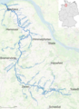
English: The Oste ['ʔo:stə] is a river in northern Lower Saxony, Germany with a length of 156 km, left tributary of the Elbe. It flows through the districts of Harburg, Rotenburg, Stade and Cuxhaven and empties into the Elbe river near Otterndorf. Its drainage area is 1.711 km² and the decline between the source and the estuary is 31 m. Tributaries are Ramme, Aue, Twiste, Bade, Bever and Mehe.
Plattdüütsch: De Oost (Oste mit 'n langet „o“ op Hauchdüütsch) is een Stroom in Neddersassen, de in de Elv/Ilv geiht.
river in Lower Saxony, Germany  El pont entre Hemmoor i Osten  | |||||
| Upload media | |||||
| Instance of | |||||
|---|---|---|---|---|---|
| Location | |||||
| Length |
| ||||
| Mouth of the watercourse | |||||
| Drainage basin | |||||
| Tributary |
| ||||
 | |||||
Subcategories
This category has the following 11 subcategories, out of 11 total.
A
- Aerial photographs of the Oste (94 F)
B
E
- Eitzter Mühle (2 F)
F
M
- Mocambo (ship, 1872) (4 F)
O
- Oste (Geversdorf) (23 F)
P
- Pegel Bremervörde (2 F)
S
- Ostesperrwerk (1 P, 32 F)
T
W
- Wassermühle Sittensen (7 F)
Media in category "Oste"
The following 68 files are in this category, out of 68 total.
-
 Verlauf der Oste.png 554 × 401; 35 KB
-
 20141109 LRWorkshop 4834.jpg 2,603 × 1,732; 2 MB
-
 Balje -Schoepfwerk an der Oste- 2007 by-RaBoe.jpg 1,600 × 735; 981 KB
-
 Balje 2006 -Mündung der Oste- by-RaBoe 02.jpg 1,576 × 1,155; 1.15 MB
-
 Balje 2009 -Bauernhaus- by-RaBoe 001.jpg 800 × 596; 430 KB
-
 Balje haus oste.JPG 1,200 × 1,600; 964 KB
-
 2008-04-03 Ostemündung Belumer Außendeich 2.JPG 3,888 × 2,592; 3.48 MB
-
 Bremervörde Minstedt Infotafel Ostebrücke.jpg 2,775 × 4,162; 2.01 MB
-
 Bremervörde Minstedt Ostebrücke.jpg 4,608 × 3,072; 9.04 MB
-
 2008-04-03 Ostemündung Belumer Außendeich 5.JPG 3,888 × 2,592; 5.24 MB
-
 Einfahrt Historischer Hafen IMG 3359 Ergebnis.jpg 1,024 × 682; 133 KB
-
 Elbe tributaries discharge diagram.svg 1,600 × 1,200; 23 KB
-
 Fähre Schönau 20150907 2.jpg 1,920 × 1,080; 1.18 MB
-
 Hamenfischer 1.JPG 3,888 × 2,592; 5.05 MB
-
 Heidenauer Aue.jpg 1,600 × 900; 354 KB
-
 Historischer Hafen bei Ebbe IMG 6820 DxO.jpg 1,024 × 682; 161 KB
-
 Infotafel Kanuwandern auf der Oste.jpg 4,000 × 3,000; 5.68 MB
-
 Jan Cux II (ship, 1978) 2009 auf der Oste (Fluss) by-RaBoe.jpg 743 × 800; 479 KB
-
 Jan Cux Schiff 06 (RaBoe).jpg 800 × 477; 329 KB
-
 Jan Cux Schiff 07 (RaBoe).jpg 800 × 522; 337 KB
-
 Jan Cux Schiff 08 (RaBoe).jpg 800 × 548; 346 KB
-
 Krabbenfischer auf der oste.jpg 700 × 412; 62 KB
-
 Neuhaus (Oste) hafen Oste 01 (RaBoe).jpg 800 × 551; 377 KB
-
 Neuhaus hafen einfahrt 01 (RaBoe.jpg 800 × 438; 330 KB
-
 Neuhaus hafen einfahrt 02 (RaBoe.jpg 800 × 600; 482 KB
-
 Neuhaus hafen einfahrt 03 (RaBoe.jpg 800 × 599; 380 KB
-
 Neuhaus jacht hafen.jpg 1,600 × 962; 1.02 MB
-
 Oberndorf an der Oste - geo.hlipp.de - 31766.jpg 640 × 480; 161 KB
-
 Oost in Bremervöör 2.jpg 1,944 × 2,592; 1.73 MB
-
 Oost in Bremervöör mit Footgängerbrügg.jpg 1,944 × 2,592; 2.05 MB
-
 Oost in Bremervöör.jpg 1,944 × 2,592; 1.75 MB
-
 Oste bei Alpershausen.jpg 2,048 × 1,536; 1.1 MB
-
 Oste bei Groß Meckelsen.jpg 2,048 × 1,536; 1.23 MB
-
 Oste einmündung elbe.jpg 1,134 × 563; 744 KB
-
 Oste in Heeslingen.jpg 2,048 × 1,536; 998 KB
-
 Oste Map.png 903 × 1,250; 1.59 MB
-
 Oste mit St.-Petri-Kirche.jpg 1,920 × 1,078; 1.82 MB
-
 Oste muendung 01.jpg 1,600 × 1,200; 426 KB
-
 Oste neuhaus ostebogen 01.jpg 1,134 × 462; 535 KB
-
 Oste river in Sittensen (1).jpg 3,949 × 2,633; 12.31 MB
-
 Oste river in Sittensen (2).jpg 3,311 × 2,209; 11.16 MB
-
 Oste river in Sittensen (3).jpg 4,325 × 2,883; 16.86 MB
-
 Oste river in Sittensen (4).jpg 3,794 × 2,529; 13.63 MB
-
 Oste schiff oste.jpg 1,541 × 993; 1.22 MB
-
 Oste Spreckens Mündung Anlegestelle 2.jpg 4,000 × 2,667; 5.22 MB
-
 Oste Spreckens Mündung Anlegestelle.jpg 4,000 × 2,667; 4.3 MB
-
 Oste.JPG 2,848 × 2,136; 2.22 MB
-
 Ostedeich bei Oberndorf.jpg 330 × 228; 28 KB
-
 Ostemündung Hullen Seehunde 01.JPG 3,888 × 2,592; 4.27 MB
-
 Ostemündung im Sonnenuntergang 2015-08-02 21.59.44.jpg 5,774 × 3,060; 2.4 MB
-
 Priggen 01.jpg 1,200 × 1,600; 919 KB
-
 Priggen 02 (RaBoe).jpg 600 × 800; 390 KB
-
 Schiff WSA Cuxhaven 01 (RaBoe).jpg 800 × 423; 360 KB
-
 Schilfguertel an der oste.jpg 2,048 × 1,536; 173 KB
-
 Schwebefähre 20131003 5.jpg 1,920 × 1,080; 1.04 MB
-
 Schöpfwerk Aue und Kanalwehr IMG 1311 DxO.jpg 1,024 × 682; 151 KB
-
 Schöppwark an dat Achthöbener Fleet 01.jpg 4,032 × 3,024; 3.25 MB
-
 Schöppwark an dat Achthöbener Fleet 02.jpg 4,032 × 3,024; 3.63 MB
-
 Schöppwark an dat Achthöbener Fleet 03.jpg 3,024 × 4,032; 3.68 MB
-
 Schöppwark an dat Achthöbener Fleet 04.jpg 3,024 × 4,032; 4.01 MB
-
 Schöppwark an dat Achthöbener Fleet 05.jpg 4,032 × 3,024; 4.63 MB
-
 Spreckens Oste-Hamme-Kanal Mündung.jpg 5,000 × 1,300; 3.31 MB
-
 Wehr in de Oost in Bremervöör 2.jpg 1,944 × 2,592; 1.34 MB
-
 Wehr in de Oost in Bremervöör 3.jpg 1,944 × 2,592; 1.74 MB
-
 Wehr in de Oost in Bremervöör.jpg 1,944 × 2,592; 1.41 MB
-
 Zeven-Brauel-Oste.JPG 900 × 600; 141 KB
-
 Zollhaus am Ostesee IMG 0650 DxO.jpg 1,024 × 682; 70 KB
-
 Zusammenfluss Oste und Ramme Nähe Sittensen.jpg 1,760 × 1,232; 1.91 MB


_2009_auf_der_Oste_(Fluss)_by-RaBoe.jpg)
.jpg)
.jpg)
.jpg)

_hafen_Oste_01_(RaBoe).jpg)


.jpg)
.jpg)
.jpg)
.jpg)


.jpg)
.jpg)


