Category:Oosterkerk, The Hague
Jump to navigation
Jump to search
| Object location | | View all coordinates using: OpenStreetMap |
|---|
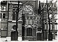
Nederlands: 's-Gravenhage, Oranjebuitensingel - Gereformeerde Oosterkerk - gebouwd 1896 - buiten gebruik 1962 - gesloopt 1988
church building in The Hague, Netherlands  | |||||
| Upload media | |||||
| Instance of | |||||
|---|---|---|---|---|---|
| Location | The Hague, South Holland, Netherlands | ||||
| Street address |
| ||||
| Architect | |||||
| Inception |
| ||||
| Dissolved, abolished or demolished date |
| ||||
| Significant event |
| ||||
| Religion or worldview |
| ||||
 | |||||
Media in category "Oosterkerk, The Hague"
The following 4 files are in this category, out of 4 total.
-
 Interieur Oosterkerk Den Haag.jpg 2,538 × 1,939; 954 KB
-
 Oosterkerk Den Haag colour.jpg 1,488 × 2,035; 452 KB
-
 Oosterkerk Den Haag.jpg 2,114 × 3,287; 1.64 MB
-
 Oosterkerk, The Hague, 1930.jpg 4,745 × 3,485; 5.83 MB


