Category:Old maps of the Atlantic Ocean
Jump to navigation
Jump to search
Subcategories
This category has the following 24 subcategories, out of 24 total.
Media in category "Old maps of the Atlantic Ocean"
The following 42 files are in this category, out of 42 total.
-
-
-

-

-

-

-
 31 of 'A History of the United States of America, etc' (11245218645).jpg 1,265 × 2,028; 498 KB
-

-

-

-
-

-

-

-
 D192- N° 455. Isthme entre l’Amérique et l’Afrique. - Liv3-Ch19.png 1,438 × 1,612; 159 KB
-
 D481- N° 397. Océan Atlantique. - liv3-ch13.png 1,460 × 1,786; 148 KB
-
 D493- N° 398. Plymouth et l’Atlantique. - liv3-ch14.png 1,444 × 1,736; 395 KB
-
 Europa Atlas Blaeuw.jpg 11,220 × 8,412; 87.16 MB
-
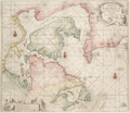
 Europa, Blaeuw.jpg 18,395 × 14,422; 78.24 MB
-
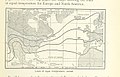
 FMIB 37995 Weather in the North Atlantic.jpeg 775 × 1,441; 255 KB
-

-
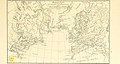
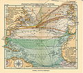
 FMIB 43893 Northern Atlantic Ocean.jpeg 2,173 × 1,575; 543 KB
-
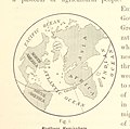
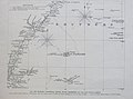
 FMIB 50009 Chart of the Atlantic Ocean.jpeg 780 × 544; 186 KB
-

-
-

-
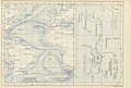
 Jamaica Map Sloane 1707 mobot31753000820123 0169.jpg 5,652 × 5,222; 3.93 MB
-
 Map of Heinrich Göring's travel to Haiti.jpg 1,186 × 770; 296 KB
-
 Nordatlantik hafen.jpg 4,563 × 3,957; 6.55 MB
-
 Nordatlantik.jpg 4,555 × 3,974; 7.33 MB
-

-
 P139 - N° 548. Routes de Paris à Rio-de-Janeiro. - Liv4-Ch06.png 1,446 × 1,856; 1.35 MB
-

-
 Phantom islands in Southern Atlantic.jpg 2,716 × 2,011; 933 KB
-
 Skálholt Map (cropped).jpg 500 × 583; 140 KB
-
 Skálholt Map.jpg 830 × 1,023; 191 KB
-
 Skálholt-Karte.png 341 × 398; 290 KB
-

-
 The botany of Iceland (1912) (20397062682).jpg 2,926 × 1,952; 1.24 MB
-

-
 Zeekaart.png 743 × 643; 1.16 MB
-

.jpg)
.jpg)
.jpg)
.jpg)
.jpg)
%27_(11233259066).jpg)
.jpg)
.jpg)
.jpg)
.jpg)
.jpg)
_-_btv1b8595162s.jpg)
.jpg)


%27_(11225171934).jpg)
%27_(11235359023).jpg)
%27_(16404371259).jpg)


.jpg)


.jpg)
_(20397062682).jpg)

.jpg)