Category:Old maps of Vanuatu
Jump to navigation
Jump to search
Subcategories
This category has only the following subcategory.
Media in category "Old maps of Vanuatu"
The following 10 files are in this category, out of 10 total.
-
 Neue Hebriden 140543a.jpg 1,038 × 1,549; 545 KB
-
-
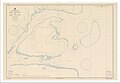
 Map of approach to Efate Island.jpg 1,184 × 1,195; 485 KB
-
 Admiralty Chart Catalogue 1967 Page 083 Index N1.jpg 8,573 × 6,867; 6.9 MB
-
 5303 Vanuatu Melanesia Eromanga Island 500K SE59-4.jpg 6,299 × 6,976; 25.33 MB
-
 Admiralty Chart No 174 South West Pacific New Hebrides Islands, Banks Group, Published 1887.jpg 6,096 × 8,023; 10.11 MB
-
 Aore US Nautical Chart 1950.jpg 15,020 × 10,418; 58.7 MB
-

-

-
 Modern travel, a record of exploration, travel (1921) (14593288338).jpg 3,472 × 2,238; 1,006 KB


_(14593288338).jpg)