Category:Old maps of Laos
Jump to navigation
Jump to search
Subcategories
This category has the following 6 subcategories, out of 6 total.
Media in category "Old maps of Laos"
The following 15 files are in this category, out of 15 total.
-
-
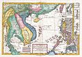
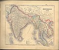
 Atlas de l'Indochine dressé (...)Indochine française bpt6k11001779 73.jpg 5,840 × 8,515; 18.28 MB
-
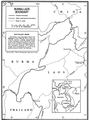 Burma - LaosBorder.png 848 × 1,142; 315 KB
-
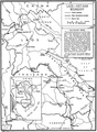
 Cambodia-Laos border.png 1,158 × 860; 337 KB
-
 Carte de la province de Savannakhet (Laos) en 1925.jpg 693 × 481; 165 KB
-
 China-Laos border map.png 850 × 1,171; 414 KB
-
 Kanpokkhrong Lao Lae Khamen, p 18.jpg 1,995 × 3,000; 981 KB
-
 Laos - Thailand border.jpg 713 × 973; 184 KB
-
 Laos - Vietnam border.png 850 × 1,155; 509 KB
-
 Meyer‘s Zeitungsatlas 054 – Ostindien.jpg 7,358 × 6,265; 15.27 MB
-
-

-
 Selden map.jpg 1,353 × 2,199; 1,008 KB
-

-


Indochine_fran%C3%A7aise_bpt6k11001779_73.jpg)


_en_1925.jpg)


.jpg)
_(14772840502).jpg)


,_Cambodia,_and_Laos_-_during_the_years_1858,_1859,_and_1860_(1864)_(14783770585).jpg)