Category:Old maps of Galle Fort
Jump to navigation
Jump to search
Media in category "Old maps of Galle Fort"
The following 11 files are in this category, out of 11 total.
-
 AMH-7263-KB Maps of the city of Punto Gale and the fort of Manaar.jpg 1,433 × 2,400; 714 KB
-
 AMH-7076-KB Map of the castle at Punto Gale.jpg 2,400 × 2,064; 1.38 MB
-
 AMH-4544-NA Map of the fort at Gale.jpg 1,478 × 2,400; 411 KB
-
 AMH-7988-KB Map of Punto Galle.jpg 1,687 × 2,400; 736 KB
-
 AMH-4546-NA Map of the fort at Gale.jpg 2,015 × 2,400; 959 KB
-

-
 0034 Point de Galle, plan (1796).jpg 778 × 1,338; 607 KB
-
 GaleFort.jpg 11,730 × 8,489; 3.44 MB
-
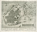
 AMH-4556-NA Bird's eye view map of the city of Gale.jpg 1,684 × 2,400; 586 KB
-
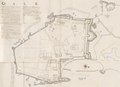
 AMH-5383-NA Map of the fortifications at Galle.jpg 2,400 × 1,691; 427 KB
-
 Gale, KITLV 500066.tif 11,730 × 8,489; 284.92 MB


.jpg)


