Category:Old maps of Fort Wayne, Indiana
Jump to navigation
Jump to search
- 100 most populous cities of the United States
- 1–25
- Boston
- Chicago
- Columbus
- Denver
- Indianapolis
- Los Angeles
- New York City
- Philadelphia
- Phoenix
- San Francisco
- San Jose
- Seattle
- Washington, D.C.
- 26–50
- Atlanta
- Baltimore
- Colorado Springs
- Detroit
- 51–75
- Cleveland
- New Orleans
- Pittsburgh
- St. Louis
- 76–100
- Baton Rouge
- Fort Wayne
- Toledo
Subcategories
This category has the following 2 subcategories, out of 2 total.
Media in category "Old maps of Fort Wayne, Indiana"
The following 12 files are in this category, out of 12 total.
-
 Bird's eye view of the city of Fort Wayne, Indiana 1868. LOC 73693381.jpg 8,992 × 6,912; 13.29 MB
-
 FortWayneIN 1868.jpg 8,992 × 6,912; 24.14 MB
-

-
 Griswold's birdseye view of the city of Fort Wayne, Indiana indexed for ready reference. LOC 75693225.tif 14,880 × 11,136; 474.08 MB
-
 Map of the city of Fort Wayne, Indiana - DPLA - fef0230d5e34775925f5530b7b322256.jpg 8,986 × 8,670; 5.04 MB
-
 Fort Wayne 1795.jpg 512 × 809; 57 KB
-
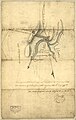
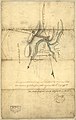
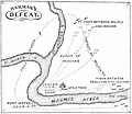 Harmar Campaign.jpg 1,245 × 1,080; 284 KB
-

-
-

-
 Map of Kekionga.jpg 734 × 571; 80 KB
-


_(14586569377).jpg)


_(14592182960).jpg)