Category:Old Wives Lees
Jump to navigation
Jump to search
village in Kent, England  | |||||
| Upload media | |||||
| Instance of | |||||
|---|---|---|---|---|---|
| Location | Chilham, Ashford, Kent, South East England, England | ||||
 | |||||
Subcategories
This category has only the following subcategory.
O
Media in category "Old Wives Lees"
The following 47 files are in this category, out of 47 total.
-
 A view across the lake - geograph.org.uk - 341190.jpg 640 × 480; 66 KB
-
 Bridleway from Stone Stile Farm - geograph.org.uk - 1490177.jpg 640 × 427; 60 KB
-
 Cashel, Old Wives Lees - geograph.org.uk - 3505468.jpg 640 × 430; 72 KB
-
 Chilham Lake - geograph.org.uk - 340938.jpg 640 × 480; 155 KB
-
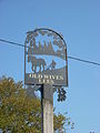
 Close-up of Old Wives Lees Village Sign - geograph.org.uk - 2105986.jpg 2,304 × 3,072; 1.6 MB
-
 Commercial orchard - geograph.org.uk - 399995.jpg 640 × 480; 77 KB
-
 Commercial orchard - geograph.org.uk - 400022.jpg 480 × 640; 79 KB
-
 Commercial orchard - geograph.org.uk - 400025.jpg 640 × 480; 100 KB
-
 Disused Pit, Lower Ensdean - geograph.org.uk - 534784.jpg 479 × 640; 220 KB
-
 Farm track to A28 Canterbury Road - geograph.org.uk - 1490263.jpg 640 × 427; 77 KB
-
 Farm track to Lower Ensden - geograph.org.uk - 1490260.jpg 640 × 427; 66 KB
-

-
 Hop poles and wires - geograph.org.uk - 411548.jpg 640 × 427; 91 KB
-
 North Downs Way in Old Wives Lees - geograph.org.uk - 1490218.jpg 640 × 427; 88 KB
-
 Old Wives Lees - geograph.org.uk - 3505460.jpg 640 × 430; 54 KB
-
 Old Wives Lees - geograph.org.uk - 3505503.jpg 640 × 430; 56 KB
-
 Old Wives Lees Methodist Church - geograph.org.uk - 1490201.jpg 640 × 427; 58 KB
-
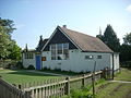
 Old Wives Lees Village Hall - geograph.org.uk - 1490224.jpg 640 × 427; 82 KB
-
 Old Wives Lees village hall - geograph.org.uk - 3204356.jpg 2,560 × 1,920; 2.25 MB
-
 Old Wives Lees Village Hall - geograph.org.uk - 3505436.jpg 640 × 430; 62 KB
-
 Old Wives Lees Village Hall - geograph.org.uk - 3505437.jpg 640 × 430; 50 KB
-
 Old Wives Lees Village Hall 01.JPG 2,816 × 2,112; 1.49 MB
-
 Old Wives Lees Village Hall 02.JPG 2,816 × 2,112; 1.46 MB
-
 Old Wives Lees village sign - geograph.org.uk - 411217.jpg 427 × 640; 104 KB
-
 Old Wives Lees Village sign.JPG 2,112 × 2,816; 1.49 MB
-
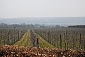
 Orchard on the North Downs way - geograph.org.uk - 48149.jpg 640 × 480; 196 KB
-
 Orchards of Kent - geograph.org.uk - 399011.jpg 640 × 480; 76 KB
-
 Orchards, Old Wives Lees - geograph.org.uk - 3515712.jpg 640 × 430; 62 KB
-
 Paddock - geograph.org.uk - 411211.jpg 640 × 427; 76 KB
-
 Path through natural trellis - geograph.org.uk - 411537.jpg 427 × 640; 150 KB
-
 Railway to Canterbury - geograph.org.uk - 1584018.jpg 640 × 427; 63 KB
-
 Recreation Ground, Old Wives Lees - geograph.org.uk - 3505429.jpg 640 × 430; 91 KB
-
 Road junction in the village centre - geograph.org.uk - 2678825.jpg 1,024 × 768; 192 KB
-
 Selling Road, Old Wives Lees - geograph.org.uk - 2824601.jpg 4,320 × 3,240; 3.38 MB
-
 Selling Tunnel - geograph.org.uk - 534774.jpg 479 × 640; 124 KB
-
 Sheep in Orchard - geograph.org.uk - 411204.jpg 640 × 427; 147 KB
-
 Shrimpton Close, Old Wives Lees - geograph.org.uk - 2824576.jpg 4,320 × 3,240; 3.24 MB
-
 Small island, Chilham Lake - geograph.org.uk - 341142.jpg 478 × 640; 77 KB
-
 Stone Stile Oast - geograph.org.uk - 400031.jpg 640 × 480; 90 KB
-
 Telephone Kiosk, Old Wives Lees - geograph.org.uk - 3505432.jpg 640 × 430; 92 KB
-

-
 The Star Inn - geograph.org.uk - 3505490.jpg 640 × 430; 84 KB
-
 The Star Inn, Old Wives Lees - geograph.org.uk - 1490209.jpg 640 × 427; 53 KB
-
 The Star Inn, Old Wives Lees - geograph.org.uk - 2824594.jpg 4,320 × 3,240; 4.13 MB
-
 Track in Joan Beech Wood (2) - geograph.org.uk - 1584033.jpg 640 × 427; 141 KB
-
 Unused stile near Chestnut Plantation - geograph.org.uk - 1490254.jpg 640 × 427; 108 KB
-
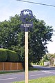
 Village Sign, Old Wives Lees - geograph.org.uk - 3505457.jpg 430 × 640; 51 KB


_-_geograph.org.uk_-_1584033.jpg)

