Category:North Downs Line
Jump to navigation
Jump to search
railway line in England, linking Reading and Redhill   | |||||
| Upload media | |||||
| Instance of | |||||
|---|---|---|---|---|---|
| Part of |
| ||||
| Location | England | ||||
| Owned by | |||||
| Operator | |||||
| Has part(s) |
| ||||
| Date of official opening |
| ||||
| |||||
Reading - Wokingham - Guildford - Dorking - Reigate - Redhill.
Subcategories
This category has the following 22 subcategories, out of 22 total.
A
B
- Betchworth railway station (40 F)
C
- Chilworth railway station (20 F)
- Crowthorne railway station (8 F)
D
- Dorking Deepdene railway station (30 F)
- Dorking West railway station (16 F)
F
G
- Gomshall railway station (20 F)
N
R
- Reigate railway station (49 F)
S
- Sandhurst railway station (7 F)
- Shalford Railway Bridge (15 F)
W
- Winnersh railway station (2 F)
Media in category "North Downs Line"
The following 34 files are in this category, out of 34 total.
-
 Aldershot, Ash, Shalford, Basingstoke, Guildford & Peasmarsh , Wimbledon RJD 4.jpg 2,861 × 1,890; 776 KB
-
 Aldershot-Guildford Line - geograph.org.uk - 602115.jpg 640 × 480; 103 KB
-
 Along the line to Reigate - geograph.org.uk - 5745402.jpg 764 × 1,024; 259 KB
-
 Blackwater River, Sandhurst - geograph.org.uk - 103083.jpg 640 × 427; 203 KB
-
 Bridleway crossing of the North Downs line - geograph.org.uk - 56862.jpg 640 × 480; 163 KB
-
 Chilworth Level Crossing - geograph.org.uk - 1763719.jpg 1,920 × 2,560; 1.81 MB
-
 Gas-holder, Farnborough - geograph.org.uk - 166204.jpg 480 × 640; 353 KB
-
 In a cutting, North Downs Line - geograph.org.uk - 5141527.jpg 640 × 402; 77 KB
-
 Level Crossing Cottage, Rectory Lane, Buckland, Surrey.jpg 3,089 × 1,853; 2.01 MB
-
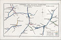
 NDLmap.png 789 × 555; 116 KB
-
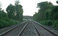 North Downs Line - geograph.org.uk - 20880.jpg 640 × 395; 68 KB
-
 North Downs Line - geograph.org.uk - 27747.jpg 640 × 480; 161 KB
-
 North Downs Line - geograph.org.uk - 72221.jpg 640 × 428; 45 KB
-
 North Downs line from Ford Crossing - geograph.org.uk - 744158.jpg 640 × 480; 168 KB
-
 North Portal of Betchworth Tunnel, Dorking (July 2013).JPG 2,200 × 1,600; 1.12 MB
-
 Railway - geograph.org.uk - 151140.jpg 480 × 640; 166 KB
-

-
 Railway Bridge over narrow country lane - geograph.org.uk - 28976.jpg 640 × 480; 207 KB
-
 Railway Bridge over Pixham Lane, Pixham (July 2013).JPG 1,900 × 1,900; 720 KB
-
 Railway crossing - geograph.org.uk - 97453.jpg 480 × 640; 84 KB
-
 Railway Crossing Point - geograph.org.uk - 151145.jpg 640 × 480; 171 KB
-
 Railway Cutting by Leasers Barn - geograph.org.uk - 818894.jpg 640 × 480; 140 KB
-

-
 Railway Line to Guildford - geograph.org.uk - 602146.jpg 640 × 480; 128 KB
-
 Railway sub-station - geograph.org.uk - 59490.jpg 640 × 427; 93 KB
-
 Railway, Chilworth - geograph.org.uk - 571292.jpg 640 × 428; 109 KB
-
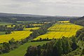 Rape fields - geograph.org.uk - 1290121.jpg 640 × 426; 79 KB
-
 Redhill - Guildford railway - geograph.org.uk - 788706.jpg 640 × 426; 70 KB
-
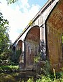 River Mole Viaduct, Pixham.jpg 2,325 × 3,000; 2.07 MB
-
 Shalford Junction, Surrey.jpg 3,872 × 2,592; 4.32 MB
-
 The North Downs Line - geograph.org.uk - 1763704.jpg 1,920 × 2,560; 1.94 MB
-
 Towards Shalford - geograph.org.uk - 1305198.jpg 640 × 427; 106 KB
-
 View off Railway Bridge in Reigate - geograph.org.uk - 29280.jpg 640 × 480; 171 KB
-
 North Downs Line - geograph.org.uk - 72217.jpg 640 × 428; 43 KB


.JPG)


.JPG)


