Category:Nieuwe Huizen 43, Breda
Jump to navigation
Jump to search
| Object location | | View all coordinates using: OpenStreetMap |
|---|
building in Breda, Netherlands  | |||||
| Upload media | |||||
| Instance of | |||||
|---|---|---|---|---|---|
| Location | Breda, North Brabant, Netherlands | ||||
| Street address |
| ||||
| Located on street |
| ||||
| Heritage designation |
| ||||
 | |||||
|
This is a category about rijksmonument number 10249
|
| Address |
|
Media in category "Nieuwe Huizen 43, Breda"
The following 7 files are in this category, out of 7 total.
-
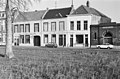
 A, voorgevels - Breda - 20041395 - RCE.jpg 1,200 × 784; 203 KB
-
 Overzicht - Breda - 20041373 - RCE.jpg 1,200 × 788; 292 KB
-
 Overzicht - Breda - 20041375 - RCE.jpg 1,200 × 804; 246 KB
-
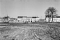 Overzicht - Breda - 20041376 - RCE.jpg 1,200 × 804; 249 KB
-
 Overzicht - Breda - 20041377 - RCE.jpg 1,200 × 799; 229 KB
-
 RM10249 Breda - Nieuwe Huizen 43.jpg 1,944 × 2,592; 1.12 MB
-
 Voorgevels - Breda - 20041396 - RCE.jpg 1,200 × 788; 227 KB


