Category:Newport, East Riding of Yorkshire
Jump to navigation
Jump to search
English: Newport is a village and civil parish in the East Riding of Yorkshire, England. It is situated approximately 7 miles (11 km) east of the market town of Howden. It lies on the B1230 road to the south of the M62 motorway. It also lies on the banks of the Market Weighton Canal.
village and civil parish in East Riding of Yorkshire, UK  | |||||
| Upload media | |||||
| Instance of | |||||
|---|---|---|---|---|---|
| Location | East Riding of Yorkshire, Yorkshire and the Humber, England | ||||
 | |||||
Subcategories
This category has only the following subcategory.
Media in category "Newport, East Riding of Yorkshire"
The following 200 files are in this category, out of 269 total.
(previous page) (next page)-
 "The Kings Arms", Newport - geograph.org.uk - 3133098.jpg 2,953 × 4,134; 3.19 MB
-
 A bridleway off Thimblehall Lane - geograph.org.uk - 3734502.jpg 1,024 × 681; 423 KB
-

-
 A Field And A Farm - geograph.org.uk - 255410.jpg 640 × 480; 105 KB
-
 A house on Canal Side West - geograph.org.uk - 2197892.jpg 800 × 600; 218 KB
-
 A minor road near Mill Lane Farm - geograph.org.uk - 3734390.jpg 1,024 × 681; 261 KB
-
 A new house on Carr Lane, East Yorkshire - geograph.org.uk - 3734529.jpg 1,024 × 681; 196 KB
-
 A very straight Wallingfen Lane near Newport - geograph.org.uk - 4489064.jpg 1,024 × 610; 88 KB
-
 A View From Seavy Carr Lane - geograph.org.uk - 255413.jpg 640 × 480; 101 KB
-
 A View To The Wolds - geograph.org.uk - 255405.jpg 640 × 480; 103 KB
-
 A63 road near Newport - geograph.org.uk - 198879.jpg 640 × 480; 147 KB
-
 Alongside the Market Weighton Canal - geograph.org.uk - 5059834.jpg 4,608 × 3,456; 4.59 MB
-
 Arriving in Newport from North Cave - geograph.org.uk - 3786385.jpg 640 × 427; 62 KB
-
 B1230 Newport East Riding of Yorkshire - geograph.org.uk - 4486084.jpg 1,024 × 742; 118 KB
-
 B1230 towards Gilberdyke - geograph.org.uk - 1603722.jpg 640 × 480; 46 KB
-
 B1230 towards North Cave - geograph.org.uk - 1603735.jpg 640 × 480; 91 KB
-
 Baling near Newport (E Yorks) - geograph.org.uk - 4609761.jpg 504 × 640; 509 KB
-
 Barns at Carr Hill Farm, East Yorkshire - geograph.org.uk - 3734563.jpg 1,024 × 681; 279 KB
-
 Bee on a teasel - geograph.org.uk - 4609762.jpg 522 × 640; 416 KB
-
 Black Dike - geograph.org.uk - 4267520.jpg 1,024 × 768; 167 KB
-
 Black Dike - geograph.org.uk - 6258516.jpg 1,024 × 768; 207 KB
-
 Bridge over River Foulness - geograph.org.uk - 1222712.jpg 640 × 480; 83 KB
-

-
 Bridge over the River Foulness - geograph.org.uk - 3725338.jpg 1,024 × 768; 146 KB
-
 Bridge over the River Foulness - geograph.org.uk - 3734637.jpg 1,024 × 681; 374 KB
-
 Bridge over the River Foulness - geograph.org.uk - 4874913.jpg 640 × 461; 381 KB
-
 Broomfleet Ponds Pumping Station - geograph.org.uk - 250290.jpg 640 × 480; 109 KB
-
 Buildings at Mill Lane Farm - geograph.org.uk - 3734384.jpg 1,024 × 681; 374 KB
-

-
 Butterfly on wheat - geograph.org.uk - 4609765.jpg 518 × 640; 458 KB
-
 Canal at Welburn House - geograph.org.uk - 175785.jpg 640 × 480; 79 KB
-
 Canal near Lorne Farm - geograph.org.uk - 746220.jpg 640 × 480; 201 KB
-

-
 Canalside footpath - geograph.org.uk - 6182068.jpg 1,024 × 768; 152 KB
-
 Canalside view - geograph.org.uk - 174305.jpg 640 × 480; 88 KB
-
 Canalside View - geograph.org.uk - 175782.jpg 640 × 480; 81 KB
-
 Car Hill Farm on Carr Lane, East Yorkshire - geograph.org.uk - 3734548.jpg 1,024 × 681; 212 KB
-
 Carr Field House on Carr Lane, East Yorkshire - geograph.org.uk - 3734534.jpg 1,024 × 681; 364 KB
-

-
 Carr Lane Farm on Carr Lane, East Yorkshire - geograph.org.uk - 3734519.jpg 1,024 × 681; 271 KB
-
 Carr Lane near Carr Hill Farm, East Yorkshire - geograph.org.uk - 3734545.jpg 1,024 × 681; 335 KB
-
 Carr Lane Nurseries on Carr Lane, East Yorkshire - geograph.org.uk - 3734537.jpg 1,024 × 681; 256 KB
-
 Carr Lane off Landing Lane, East Yorkshire - geograph.org.uk - 3734514.jpg 1,024 × 681; 256 KB
-
 Carr Lane off Landing Lane, East Yorkshire - geograph.org.uk - 3734521.jpg 1,024 × 681; 235 KB
-
 Carr Lane off Landing Lane, East Yorkshire. - geograph.org.uk - 3734564.jpg 1,024 × 681; 258 KB
-
 Carr Lane off Landing Lane, East Yorkshire. - geograph.org.uk - 3734574.jpg 1,024 × 681; 218 KB
-
 Carr Lane to Sand Hill Farm - geograph.org.uk - 1365170.jpg 640 × 480; 40 KB
-
 Carr Lane towards Sand Hill Farm - geograph.org.uk - 3734582.jpg 1,024 × 681; 216 KB
-
 Carrhill Farm Carr Lane - geograph.org.uk - 5060232.jpg 4,608 × 3,456; 3.92 MB
-
 Clegdike Bridge - geograph.org.uk - 1466221.jpg 640 × 480; 46 KB
-
 Clegdike Drain - geograph.org.uk - 733097.jpg 480 × 640; 152 KB
-

-
-

-
 Cottages and Wallingfen Chapel - geograph.org.uk - 4267926.jpg 1,024 × 768; 160 KB
-
 Cut vegetation floating in the Canal - geograph.org.uk - 2185502.jpg 3,000 × 4,000; 3.82 MB
-

-
 Dragonfly on grass stems - geograph.org.uk - 4609830.jpg 548 × 640; 513 KB
-
 Drain beside Main Road, Newport - geograph.org.uk - 5664127.jpg 640 × 480; 92 KB
-
 Drain Lane towards Sandholme Lodge - geograph.org.uk - 2023828.jpg 640 × 480; 91 KB
-
 Drain near Sand Hill Farm - geograph.org.uk - 6027464.jpg 1,024 × 768; 162 KB
-
 Drain off Marr Lane - geograph.org.uk - 4239282.jpg 1,024 × 768; 175 KB
-
 Elizabeth II postbox on Main Road, Newport - geograph.org.uk - 5664024.jpg 1,075 × 2,038; 487 KB
-
 Elizabeth II postbox on Wallingfen Lane, Newport - geograph.org.uk - 5664449.jpg 2,848 × 2,136; 1.56 MB
-
 Elm Cottage on Landing Lane, East Yorkshire - geograph.org.uk - 3734512.jpg 1,024 × 681; 285 KB
-
 Elm Tree Farm, near Newport - geograph.org.uk - 733119.jpg 601 × 640; 197 KB
-
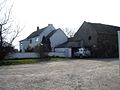
 Farm at Newport - geograph.org.uk - 114800.jpg 640 × 480; 160 KB
-

-
 Farm building on Main Road, Newport - geograph.org.uk - 5663694.jpg 640 × 458; 95 KB
-
 Farm buildings on Carr Lane, East Yorkshire - geograph.org.uk - 3734524.jpg 1,024 × 681; 316 KB
-

-
 Farm track by Welburn House - geograph.org.uk - 6027469.jpg 1,024 × 768; 360 KB
-
 Farm track to Hasholme Garth, East Yorkshire. - geograph.org.uk - 3734618.jpg 1,024 × 681; 220 KB
-
 Farmland - geograph.org.uk - 174192.jpg 640 × 480; 80 KB
-
 Farmland at SE872301 - geograph.org.uk - 121389.jpg 640 × 480; 166 KB
-
 Farmland near Sandholme Landing - geograph.org.uk - 2023843.jpg 640 × 480; 61 KB
-
 Farmland near Sandholme Landing - geograph.org.uk - 2023857.jpg 640 × 480; 78 KB
-
 Farmland off Wallingfen Lane - geograph.org.uk - 4489067.jpg 1,024 × 695; 156 KB
-
 Fenland Lane - geograph.org.uk - 6021846.jpg 640 × 480; 72 KB
-

-
 Field path near Sandholme - geograph.org.uk - 6027546.jpg 1,024 × 768; 239 KB
-
 Fishing ponds, Newport - geograph.org.uk - 745256.jpg 480 × 640; 183 KB
-
 Footbridge over the B1230 at Newport.jpg 640 × 480; 78 KB
-
 Footpath between fields and Market Weighton Canal - geograph.org.uk - 5059895.jpg 3,456 × 4,608; 4.76 MB
-
 Footpath by the Market Weighton Canal - geograph.org.uk - 6182064.jpg 1,024 × 768; 176 KB
-
 Footpath from Newport to River Humber - geograph.org.uk - 5059852.jpg 4,608 × 3,456; 4.67 MB
-

-
 Gate at the end of Marr Lane - geograph.org.uk - 1369722.jpg 640 × 388; 80 KB
-
 Geographer Impeded - geograph.org.uk - 255407.jpg 640 × 480; 109 KB
-
 George V postbox on Main Road, Newport - geograph.org.uk - 5663693.jpg 1,139 × 1,995; 553 KB
-
 Glasshouses and wind turbine - geograph.org.uk - 5073975.jpg 1,024 × 637; 96 KB
-
 Glasshouses. packing shed and heating plant - geograph.org.uk - 4267904.jpg 1,024 × 768; 130 KB
-
 Grazing near Carr Lane Farm - geograph.org.uk - 5664124.jpg 2,848 × 2,136; 1.48 MB
-
 Happy Birthday Tom - geograph.org.uk - 3734387.jpg 1,024 × 681; 260 KB
-
 Heading North towards Newport - geograph.org.uk - 2106476.jpg 800 × 600; 267 KB
-
 Hedon Salads, Newport - geograph.org.uk - 745022.jpg 640 × 440; 163 KB
-
 Higham Grange, near Newport (E Yorks) - geograph.org.uk - 4609821.jpg 480 × 640; 487 KB
-
 Hopwood Lane - geograph.org.uk - 3786533.jpg 640 × 427; 56 KB
-
 Hopwood Lane - geograph.org.uk - 4266485.jpg 1,024 × 768; 229 KB
-
 Hopwood Lane - geograph.org.uk - 6182070.jpg 1,024 × 768; 212 KB
-
 Hopwood Lane, Newport - geograph.org.uk - 2106491.jpg 800 × 600; 270 KB
-
 Houses alongside the B1230 toward North Cave (2) - geograph.org.uk - 5110573.jpg 3,079 × 1,953; 1.86 MB
-
 Houses alongside the B1230 toward North Cave - geograph.org.uk - 5110555.jpg 2,916 × 2,075; 1.69 MB
-
 Houses on Canal Side East - geograph.org.uk - 4267917.jpg 1,024 × 768; 252 KB
-
 Houses on Main Road, Newport - geograph.org.uk - 4267912.jpg 1,024 × 768; 220 KB
-
 Industrial buildings near Newport - geograph.org.uk - 5437729.jpg 800 × 600; 124 KB
-

-
 Landing Lane, Cow Bridge - geograph.org.uk - 5664122.jpg 640 × 480; 105 KB
-
 Landing Lane, Newport - geograph.org.uk - 2197883.jpg 800 × 600; 197 KB
-
 Landing Lane, Sandholme Landing - geograph.org.uk - 2023848.jpg 640 × 480; 101 KB
-
 Landing Lane, Sandholme Landing - geograph.org.uk - 5663560.jpg 640 × 480; 106 KB
-
 Lane from Welburn House - geograph.org.uk - 175787.jpg 640 × 480; 129 KB
-
 Lone tree - geograph.org.uk - 4267534.jpg 1,024 × 768; 177 KB
-

-
 Lorne Farm - geograph.org.uk - 4265870.jpg 1,024 × 768; 210 KB
-
 Lorne Farm - geograph.org.uk - 4267539.jpg 1,024 × 768; 194 KB
-

-

-

-
 M62 junction 38 lane guidance gantry - geograph.org.uk - 1466686.jpg 640 × 398; 35 KB
-
 M62 near Mill Lane Farm - geograph.org.uk - 5925056.jpg 1,024 × 723; 109 KB
-
 M62 towards Hull (geograph 5664126).jpg 640 × 480; 46 KB
-
 Main Road (B1230), Newport - geograph.org.uk - 5663697.jpg 2,848 × 2,136; 1.28 MB
-
 Main Road B1230 Newport - geograph.org.uk - 5060337.jpg 4,608 × 3,456; 3.52 MB
-
 Main Road, Newport - geograph.org.uk - 2106485.jpg 800 × 600; 239 KB
-
 Main Road, Newport - geograph.org.uk - 5664028.jpg 2,848 × 2,136; 1.13 MB
-
 Main Road, Newport, East Yorkshire - geograph.org.uk - 3729678.jpg 1,024 × 681; 241 KB
-
 Market Weighton Canal - geograph.org.uk - 174200.jpg 640 × 480; 70 KB
-
 Market Weighton Canal - geograph.org.uk - 174301.jpg 640 × 480; 82 KB
-
 Market Weighton Canal - geograph.org.uk - 2023862.jpg 640 × 480; 88 KB
-
 Market Weighton Canal - geograph.org.uk - 3786544.jpg 640 × 427; 72 KB
-
 Market Weighton Canal 1.jpg 640 × 480; 65 KB
-

-
 Market Weighton Canal and Lorne Farm - geograph.org.uk - 1222689.jpg 640 × 480; 78 KB
-
 Market Weighton Canal at Welburn House - geograph.org.uk - 175784.jpg 640 × 480; 116 KB
-
 Market Weighton Canal Bridges - geograph.org.uk - 1753297.jpg 6,416 × 4,208; 2.02 MB
-

-

-

-
 Market Weighton Canal, Newport - geograph.org.uk - 5664132.jpg 2,848 × 2,136; 1.43 MB
-
 Market Weighton Canal, Newport - geograph.org.uk - 6020320.jpg 1,024 × 768; 219 KB
-

-

-
 Mill Lane near Mill Lane Farm, Newport - geograph.org.uk - 3734375.jpg 1,024 × 681; 324 KB
-
 Mill Lane near Mill Lane Farm, Newport - geograph.org.uk - 3734377.jpg 1,024 × 681; 286 KB
-
 Mill Lane west of Newport - geograph.org.uk - 2185529.jpg 4,000 × 3,000; 2.55 MB
-
 Mill Lane, Newport, East Yorkshire - geograph.org.uk - 3734372.jpg 1,024 × 681; 179 KB
-
 Mill Lane, Newport, East Yorkshire - geograph.org.uk - 3734373.jpg 1,024 × 681; 183 KB
-
 Minor Road with M62 to the left - geograph.org.uk - 2185542.jpg 4,000 × 3,000; 2.62 MB
-
 Motorway Pond, Newport - geograph.org.uk - 596092.jpg 640 × 452; 50 KB
-
 Newport 4 Parishes Walk Marker - geograph.org.uk - 3734501.jpg 1,024 × 681; 196 KB
-
 Newport East Riding of Yorkshire - geograph.org.uk - 4486081.jpg 1,024 × 768; 132 KB
-
 Newport House Farm - geograph.org.uk - 4267883.jpg 1,024 × 768; 200 KB
-
 Newport News and Off Licence - geograph.org.uk - 4158219.jpg 1,600 × 1,064; 573 KB
-
 Newport Primary School - geograph.org.uk - 3786556.jpg 640 × 427; 49 KB
-
 Newport Primary School - geograph.org.uk - 3786559.jpg 640 × 427; 78 KB
-
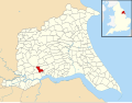 Newport, East Riding of Yorkshire UK parish locator map.svg 1,425 × 1,107; 1.68 MB
-
 Newport, East Riding of Yorkshire.jpg 640 × 480; 109 KB
-
 O-S Benchmark on brick farm building at Carrhill Farm - geograph.org.uk - 5060240.jpg 4,608 × 3,456; 5.51 MB
-
 Oak Tree Farm on Carr Lane, East Yorkshire - geograph.org.uk - 3734567.jpg 1,024 × 681; 386 KB
-
 Oak Tree Farm on Carr Lane, East Yorkshire - geograph.org.uk - 3734570.jpg 1,024 × 681; 328 KB
-
 Over Market Weighton Canal farm vehicles - geograph.org.uk - 5059909.jpg 4,608 × 3,456; 5.02 MB
-
 Path towards the motorway - geograph.org.uk - 4265884.jpg 1,024 × 768; 296 KB
-
 Pig Sheds near Sand Hill Farm, East Yorkshire. - geograph.org.uk - 3734615.jpg 1,024 × 681; 186 KB
-
 Pig Sheds near Sand Hill Farm, East Yorkshire. - geograph.org.uk - 3734621.jpg 1,024 × 681; 181 KB
-
 Ploughfurrow Drain - geograph.org.uk - 745092.jpg 480 × 640; 156 KB
-

-
 Public Bridleway - geograph.org.uk - 689781.jpg 480 × 640; 66 KB
-
 Pumping station pipes - geograph.org.uk - 745188.jpg 480 × 640; 176 KB
-
 Reservoir near Newport - geograph.org.uk - 6027480.jpg 1,024 × 768; 198 KB
-
 River Foulness and Market Weighton Canal - geograph.org.uk - 138925.jpg 640 × 480; 103 KB
-

-
 River Foulness near Hasholme Garth - geograph.org.uk - 4874826.jpg 480 × 640; 408 KB
-
 Road at Marr Grange Fish Farm - geograph.org.uk - 235999.jpg 640 × 426; 114 KB
-

-

-

-
 Rowan or Mountain Ash alongside Landing Lane - geograph.org.uk - 5059950.jpg 3,456 × 4,608; 5.43 MB
-
 Saltmarsh Grange - geograph.org.uk - 1603742.jpg 640 × 459; 65 KB
-
 Saltmarsh Grange - geograph.org.uk - 5439447.jpg 800 × 600; 119 KB
-
 Saltmarsh Grange, Newport - geograph.org.uk - 1466257.jpg 640 × 480; 52 KB
-
 Sand Hill Farm Sandholme.jpg 640 × 480; 68 KB
-
 Sand Hill Farm, East Yorkshire. - geograph.org.uk - 3734589.jpg 1,024 × 681; 245 KB
-
 Sand Hill Farm, East Yorkshire. - geograph.org.uk - 3734590.jpg 1,024 × 681; 258 KB
-
 Sand Hill Farm, East Yorkshire. - geograph.org.uk - 3734592.jpg 1,024 × 681; 267 KB
-
 Sand Hill Farm, East Yorkshire. - geograph.org.uk - 3734611.jpg 1,024 × 681; 317 KB
-
 Sandholme Landing - geograph.org.uk - 174310.jpg 640 × 480; 104 KB
-
 Sandholme Lodge Holiday Park - geograph.org.uk - 174189.jpg 640 × 480; 75 KB
-
 Seavy Carr Drain - geograph.org.uk - 745154.jpg 480 × 640; 160 KB
-
 Seavy Carr Drain and Pumping Station - geograph.org.uk - 1222676.jpg 640 × 480; 50 KB
-
 Seavy Carr pumping station - geograph.org.uk - 745175.jpg 640 × 480; 153 KB
-
 Seven swans a-swimming - geograph.org.uk - 4265864.jpg 1,024 × 768; 210 KB
-
 Sign at New Village House Farm - geograph.org.uk - 239149.jpg 640 × 426; 103 KB
-

-
 Sign for the Jolly Sailor, Newport - geograph.org.uk - 5664143.jpg 323 × 640; 44 KB
-
 Sign for the Kings Arms, Newport - geograph.org.uk - 5664138.jpg 463 × 640; 69 KB
-
 Signpost on Landing Lane, East Yorkshire - geograph.org.uk - 3734507.jpg 1,024 × 681; 322 KB
-
 Skelton Grange - geograph.org.uk - 115324.jpg 640 × 480; 165 KB
-
 Skelton Grange - geograph.org.uk - 1603745.jpg 640 × 480; 50 KB
-
 Sluice and the Market Weighton Canal - geograph.org.uk - 4265880.jpg 1,024 × 768; 171 KB


_-_geograph.org.uk_-_4609761.jpg)


_-_geograph.org.uk_-_4609821.jpg)


_-_geograph.org.uk_-_5110573.jpg)


_-_geograph.org.uk_-_235412.jpg)


_-_geograph.org.uk_-_2197899.jpg)


.jpg)
,_Newport_-_geograph.org.uk_-_5663697.jpg)


_-_geograph.org.uk_-_4609764.jpg)


_(30383272301).jpg)


