Category:Neuapostolische Kirche in Elsterwerda
Jump to navigation
Jump to search
| Object location | | View all coordinates using: OpenStreetMap |
|---|
church building in Brandenburg state, Germany  | |||||
| Upload media | |||||
| Instance of | |||||
|---|---|---|---|---|---|
| Location | Elsterwerda, Elbe-Elster District, Brandenburg, Germany | ||||
| Street address |
| ||||
| Inception |
| ||||
| Date of official closure |
| ||||
| Religion or worldview | |||||
 | |||||
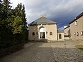
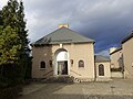
English: Pictures of the former New Apostolic church in Elsterwerda, Elsterwerda municipality, Elbe-Elster district, Brandenburg state, Deutschland.
Deutsch: Ansichten der früheren Neuapostolischen Kirche in Elsterwerda, Stadt Elsterwerda , Landkreis Elbe-Elster , Land Brandenburg , Germany.
Français : Photos de l'ancien temple néo-apostolique à Elsterwerda, ville de Elsterwerda, , arrondissement de Elbe-Elster , état federé de Brandebourg , Allemagne.
Español: Vistas del antiguo templo neo-apostolico en Elsterwerda, ciudad de Elsterwerda, , distrito de Elbe-Elster , estado federado de Brandeburgo , Alemania.
Address: Feldstraße 8, 04910 Elsterwerda
Media in category "Neuapostolische Kirche in Elsterwerda"
The following 4 files are in this category, out of 4 total.
-
 Neuapostolische Kirche Feldstraße Eda Jan 2018 P1110879.jpg 4,608 × 3,456; 1.71 MB
-
 Neuapostolische Kirche Feldstraße Eda Jan 2018 P1110880.jpg 3,353 × 2,516; 876 KB
-
 Neuapostolische Kirche Feldstraße Eda Jan 2018 P1110889.jpg 4,608 × 3,456; 1.94 MB
-
 Neuapostolische Kirche Straße an der Eisenbahn Eda Jan 2018 P1110865.jpg 4,608 × 3,456; 1.94 MB


