Category:Nettlebed
Jump to navigation
Jump to search
village and civil parish in South Oxfordshire district, Oxfordshire, England .JPG) | |||||
| Upload media | |||||
| Instance of | |||||
|---|---|---|---|---|---|
| Location | South Oxfordshire, Oxfordshire, South East England, England | ||||
| Area |
| ||||
| official website | |||||
 | |||||
Subcategories
This category has the following 6 subcategories, out of 6 total.
B
C
H
- Myrtles, Nettlebed (2 F)
J
- Joyce Grove (4 F)
K
- Nettlebed Kiln (3 F)
W
- The White Hart, Nettlebed (3 F)
Media in category "Nettlebed"
The following 200 files are in this category, out of 366 total.
(previous page) (next page)-
 18th C. Granary - geograph.org.uk - 2918154.jpg 3,072 × 2,383; 1.76 MB
-
 343 Engineers US Army 1942 - geograph.org.uk - 3511281.jpg 3,028 × 2,232; 2.27 MB
-
 A4130 east of Offal Wood - geograph.org.uk - 2918345.jpg 3,203 × 2,477; 1.46 MB
-
 A4130 heading SE at Catslip - geograph.org.uk - 5331884.jpg 1,024 × 683; 276 KB
-
 A4130 Port Hill - geograph.org.uk - 6236438.jpg 1,024 × 684; 442 KB
-
 A4130 south of Halfridge - geograph.org.uk - 2918164.jpg 3,564 × 2,627; 1.91 MB
-
 A4130 towards Wallingford - geograph.org.uk - 6236355.jpg 1,024 × 684; 516 KB
-
 A4130 towards Wallingford - geograph.org.uk - 6236360.jpg 1,024 × 684; 389 KB
-
 Altar at St Bartholomew - geograph.org.uk - 5176307.jpg 1,024 × 683; 122 KB
-
 Altar at the Base - geograph.org.uk - 5178948.jpg 533 × 800; 75 KB
-
 Altar ^ Chancel Window - geograph.org.uk - 5176304.jpg 533 × 800; 77 KB
-
 Angel on the Cross - geograph.org.uk - 5187061.jpg 533 × 800; 115 KB
-
 Approaching Magpies - geograph.org.uk - 2133472.jpg 640 × 426; 212 KB
-
 B481 beside Copse Wood - geograph.org.uk - 2890794.jpg 3,648 × 2,406; 1.34 MB
-
 B481 traverses Lower Common Wood - geograph.org.uk - 2890256.jpg 3,066 × 2,333; 1.57 MB
-
 Back of the Lych Gate - geograph.org.uk - 5188121.jpg 533 × 800; 125 KB
-
 Back of the Milestone - geograph.org.uk - 2687214.jpg 533 × 800; 187 KB
-
 Balcony View - geograph.org.uk - 5185613.jpg 1,024 × 683; 104 KB
-
 Barry Vault - geograph.org.uk - 5187154.jpg 1,024 × 683; 212 KB
-
 Beech woodland in April, Nettlebed Woods - geograph.org.uk - 6130562.jpg 1,024 × 768; 371 KB
-
 Benchmark on 'The Cottage' - geograph.org.uk - 5583438.jpg 683 × 1,024; 311 KB
-
 Benchmark on St Bartholomew's Church - geograph.org.uk - 5332496.jpg 683 × 1,024; 312 KB
-
 Benchmark on the kerb at east end of High Street - geograph.org.uk - 5331934.jpg 1,024 × 683; 346 KB
-
 Benchmark on The Lodge at Crockerend - geograph.org.uk - 5583375.jpg 642 × 1,024; 246 KB
-
 Benchmark on the Red Lion - geograph.org.uk - 2617937.jpg 533 × 800; 181 KB
-
 Benchmark on ^1 High Street - geograph.org.uk - 5332003.jpg 665 × 1,024; 293 KB
-
 Bennett memorial - geograph.org.uk - 5177420.jpg 533 × 800; 84 KB
-
 BP petrol station on Port Hill, Nettlebed - geograph.org.uk - 4973001.jpg 2,304 × 1,728; 841 KB
-
 BP petrol station on Port Hill, Nettlebed - geograph.org.uk - 4973007.jpg 2,304 × 1,728; 827 KB
-
 Brick Chest Tomb - geograph.org.uk - 5188127.jpg 1,024 × 683; 206 KB
-
 Brick kiln, Nettlebed - geograph.org.uk - 6163160.jpg 3,840 × 2,160; 3.99 MB
-
 Brick-making kiln - geograph.org.uk - 3896787.jpg 3,240 × 4,320; 4.55 MB
-

-
 Brights of Nettlebed - geograph.org.uk - 2496341.jpg 1,024 × 683; 138 KB
-
 Broken Pillar - geograph.org.uk - 5185884.jpg 1,024 × 683; 195 KB
-
 Broken wall at Nettlebed churchyard - geograph.org.uk - 2111789.jpg 640 × 427; 192 KB
-
 Bugatti in the window - geograph.org.uk - 2496340.jpg 1,024 × 683; 131 KB
-
 Building in the wood - geograph.org.uk - 2491567.jpg 1,024 × 768; 235 KB
-
 Building on the end - geograph.org.uk - 2491587.jpg 1,024 × 768; 249 KB
-
 Bus shelter on The Green, Nettlebed - geograph.org.uk - 4972585.jpg 2,048 × 1,536; 1.56 MB
-
 Bus stop at Nettlebed - geograph.org.uk - 2107063.jpg 640 × 427; 244 KB
-
 Buttresses on the tower - geograph.org.uk - 2494538.jpg 1,024 × 683; 160 KB
-
 Byway junction - geograph.org.uk - 1049369.jpg 640 × 427; 173 KB
-
 Catslip, Nettlebed - geograph.org.uk - 2178719.jpg 640 × 480; 118 KB
-
 Celia Johnson ^ Peter Fleming - geograph.org.uk - 5188450.jpg 600 × 800; 146 KB
-
 Centre memorial - geograph.org.uk - 5178818.jpg 533 × 800; 72 KB
-
 Centre Memorial Detail - geograph.org.uk - 5178814.jpg 533 × 800; 74 KB
-
 Chair by the Arch - geograph.org.uk - 5177339.jpg 533 × 800; 71 KB
-
 Chancel arch Memorials - geograph.org.uk - 5177419.jpg 533 × 800; 82 KB
-
 Chancel in St Bartholomew - geograph.org.uk - 5176302.jpg 533 × 800; 82 KB
-
 Chancel Window at St Bartholomew - geograph.org.uk - 5176305.jpg 533 × 800; 109 KB
-
 Chiltern Way - geograph.org.uk - 1270060.jpg 640 × 480; 164 KB
-
 Church and Plough - geograph.org.uk - 2889591.jpg 787 × 1,024; 194 KB
-
 Church Banner - geograph.org.uk - 5177353.jpg 533 × 800; 51 KB
-
 Church from ground level - geograph.org.uk - 5188338.jpg 1,024 × 683; 157 KB
-
 Church of St Bartholomew - geograph.org.uk - 2890560.jpg 3,648 × 2,736; 1.14 MB
-
 Churchyard and tower - geograph.org.uk - 2494542.jpg 533 × 800; 112 KB
-
 Churchyard at St Bartholomew Nettlebed - geograph.org.uk - 5185749.jpg 1,024 × 683; 171 KB
-
 Churchyard at St Bartholomew Nettlebed - geograph.org.uk - 5187058.jpg 1,024 × 683; 149 KB
-
 Churchyard near the East End - geograph.org.uk - 5185745.jpg 1,024 × 683; 207 KB
-
 Clarke Memorial - geograph.org.uk - 5177561.jpg 533 × 800; 57 KB
-
 Clearing near the building - geograph.org.uk - 2491581.jpg 1,024 × 768; 313 KB
-
 Closed on Watlington Street - geograph.org.uk - 2617840.jpg 1,024 × 683; 125 KB
-
 Club in the village - geograph.org.uk - 2494958.jpg 1,024 × 683; 120 KB
-
 Coat of Arms - geograph.org.uk - 5178942.jpg 1,024 × 683; 85 KB
-
 Cottage at Nettlebed - geograph.org.uk - 2133520.jpg 640 × 426; 226 KB
-
 Cottages in Mill Road - geograph.org.uk - 54413.jpg 640 × 481; 62 KB
-
 Crocker End SPS - geograph.org.uk - 2169091.jpg 3,648 × 2,736; 2.83 MB
-
 Crockerend Green - geograph.org.uk - 3834348.jpg 640 × 480; 192 KB
-
 Crockerend, The Lodge - geograph.org.uk - 5583397.jpg 1,024 × 683; 144 KB
-
 Cross beside the door - geograph.org.uk - 5188333.jpg 1,024 × 683; 179 KB
-
 Cyclists in Nott Wood - geograph.org.uk - 595734.jpg 640 × 477; 89 KB
-
 Door in the tower - geograph.org.uk - 2619105.jpg 533 × 800; 137 KB
-
 Door to the nave - geograph.org.uk - 5187155.jpg 533 × 800; 115 KB
-
 Doors on the building - geograph.org.uk - 2491573.jpg 1,024 × 768; 354 KB
-
 Entering Nettlebed - geograph.org.uk - 2111773.jpg 640 × 427; 203 KB
-
 Entrance to the Bull - geograph.org.uk - 2496124.jpg 426 × 640; 90 KB
-
 Entrance to the Inn - geograph.org.uk - 2496120.jpg 1,024 × 683; 164 KB
-
 Eskan Headstone - geograph.org.uk - 5187143.jpg 533 × 800; 118 KB
-
 Esmee ^ John Ward - geograph.org.uk - 5187152.jpg 533 × 800; 118 KB
-
 Evelyn St. Croix Fleming - geograph.org.uk - 5188456.jpg 600 × 800; 108 KB
-
 Exchange through the gate - geograph.org.uk - 2619069.jpg 1,024 × 683; 215 KB
-
 Farmland and woodland edge, Nettlebed - geograph.org.uk - 1270522.jpg 640 × 480; 228 KB
-
 Farmland near Huntercombe - geograph.org.uk - 3201268.jpg 3,888 × 2,592; 2.63 MB
-
 Felled trees on the edge of Nettlebed Common Wood - geograph.org.uk - 6109829.jpg 6,000 × 4,000; 6.74 MB
-
 Fenced Tomb - geograph.org.uk - 5188116.jpg 1,024 × 683; 217 KB
-
 Field boundary near Shepherds Barn - geograph.org.uk - 2133458.jpg 640 × 427; 210 KB
-
 Fleming Family Graves - geograph.org.uk - 5185880.jpg 1,024 × 683; 189 KB
-
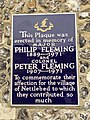 Fleming plaque, Nettlebed (35520683083).jpg 2,448 × 3,264; 2.41 MB
-
 Fleming Window Detail 1 - geograph.org.uk - 5185616.jpg 1,024 × 683; 159 KB
-
 Fleming Window Detail 3 - geograph.org.uk - 5185620.jpg 533 × 800; 137 KB
-
 Fleming Window Detail 4 - geograph.org.uk - 5185621.jpg 533 × 800; 129 KB
-
 Fleming Window Detail 5 - geograph.org.uk - 5185623.jpg 1,024 × 683; 96 KB
-
 Font below the Window - geograph.org.uk - 5185734.jpg 533 × 800; 62 KB
-
 Font beside the Door - geograph.org.uk - 5188334.jpg 533 × 800; 116 KB
-
 Font in St Bartholomew - geograph.org.uk - 5176197.jpg 533 × 800; 75 KB
-
 Footpath adjacent to Halfridge, Catslip - geograph.org.uk - 2178787.jpg 640 × 480; 144 KB
-
 Footpath in Halfridge Wood, Nettlebed - geograph.org.uk - 2122898.jpg 480 × 640; 179 KB
-
 Footpath on the corner - geograph.org.uk - 2494945.jpg 1,024 × 683; 238 KB
-
 Footpath to Nettlebed - geograph.org.uk - 54418.jpg 640 × 481; 47 KB
-
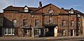
 Former coaching inn - geograph.org.uk - 2111781.jpg 640 × 427; 209 KB
-
 Former Nettlebed Baptist Chapel - geograph.org.uk - 3662781.jpg 3,617 × 2,551; 2.94 MB
-
 Four Crosses - geograph.org.uk - 5187055.jpg 1,024 × 683; 163 KB
-
 From the Door - geograph.org.uk - 5176195.jpg 1,024 × 683; 90 KB
-
 Gateway beside Nettlebed to Bix Bottom footpath - geograph.org.uk - 5331917.jpg 1,024 × 683; 202 KB
-
 Grave and chest tomb - geograph.org.uk - 5188240.jpg 1,024 × 683; 201 KB
-
 Harris Memorial - geograph.org.uk - 5178680.jpg 533 × 800; 88 KB
-
 Harris Memorial Base - geograph.org.uk - 5178831.jpg 1,024 × 683; 114 KB
-
 Harris Memorial Detail 1 - geograph.org.uk - 5178820.jpg 533 × 800; 89 KB
-
 Harris memorial Detail 2 - geograph.org.uk - 5178824.jpg 533 × 800; 85 KB
-
 Harris Memorial Detail 3 - geograph.org.uk - 5178828.jpg 533 × 800; 89 KB
-
 Harris memorial Detail 4 - geograph.org.uk - 5178834.jpg 533 × 800; 89 KB
-
 Harris Memorial Detail 5 - geograph.org.uk - 5178837.jpg 533 × 800; 73 KB
-
 Harris Memorial Inscription - geograph.org.uk - 5178683.jpg 533 × 800; 82 KB
-
 Headstone beside the Wall - geograph.org.uk - 5188132.jpg 1,024 × 683; 227 KB
-
 Headstone Carving - geograph.org.uk - 5185885.jpg 533 × 800; 108 KB
-
 Headstop by the Pulpit - geograph.org.uk - 5177349.jpg 1,024 × 683; 85 KB
-
 Hedge across the road - geograph.org.uk - 2492428.jpg 1,024 × 683; 155 KB
-
 Henry Algernon Baumgartner - geograph.org.uk - 5177423.jpg 1,024 × 683; 84 KB
-
 Hidden by the road - geograph.org.uk - 2687022.jpg 1,024 × 683; 237 KB
-
 Nettlebed BullInn.jpg 1,280 × 614; 498 KB
-
 Nettlebed HighSt 13–17.jpg 1,280 × 1,230; 673 KB
-
 Nettlebed HighSt 1–3 north.jpg 1,280 × 643; 528 KB
-
 Nettlebed HighSt 22.jpg 1,279 × 1,280; 620 KB
-
 Nettlebed HighSt 25.jpg 1,280 × 719; 586 KB
-
 Nettlebed HighSt 4–12.jpg 1,280 × 602; 418 KB
-
 Nettlebed HighSt 7.jpg 1,280 × 1,280; 726 KB
-
 Nettlebed HighSt 9–11.jpg 1,280 × 1,280; 596 KB
-
 High Street, Nettlebed - geograph-5294834.jpg 1,486 × 1,018; 244 KB
-
 Hole near the path - geograph.org.uk - 2490595.jpg 1,024 × 768; 322 KB
-
 Horse chestnut near Crocker End - geograph.org.uk - 557809.jpg 477 × 640; 99 KB
-
 House and plants at Catslip - geograph.org.uk - 557818.jpg 640 × 477; 139 KB
-
 House at Crocker End - geograph.org.uk - 557815.jpg 640 × 477; 99 KB
-
 House at Windmill Hill - geograph.org.uk - 2133481.jpg 640 × 426; 208 KB
-
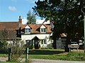
 House by the Nature Reserve - geograph.org.uk - 1655053.jpg 640 × 424; 81 KB
-
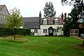
 House in the centre of Nettlebed - geograph.org.uk - 4835738.jpg 2,304 × 1,728; 802 KB
-
 Huntercombe End - geograph.org.uk - 2889578.jpg 640 × 547; 103 KB
-
 Huntercombe End Lane - geograph.org.uk - 1713129.jpg 2,592 × 1,944; 2.04 MB
-
 In Memory of Philip ^ Peter Fleming - geograph.org.uk - 2495286.jpg 1,024 × 683; 256 KB
-
 Information Board at Warburg Nature Reserve (1) - geograph.org.uk - 6181918.jpg 2,592 × 1,944; 1.42 MB
-
 Information on the Kiln - geograph.org.uk - 2617971.jpg 1,024 × 683; 164 KB
-
 Inscription on the Headstone - geograph.org.uk - 5188452.jpg 1,024 × 768; 194 KB
-
 Inscription over the Lych gate - geograph.org.uk - 2492447.jpg 1,024 × 683; 147 KB
-
 Inside the building - geograph.org.uk - 2491309.jpg 1,024 × 768; 322 KB
-
 Inside the Kiln - geograph.org.uk - 2619060.jpg 1,024 × 683; 187 KB
-
 Ivy round the Pillar - geograph.org.uk - 5185886.jpg 533 × 800; 113 KB
-
-
 Junction of B481 and A4130 - geograph.org.uk - 2890509.jpg 3,092 × 2,384; 1.67 MB
-
 Lancet Window - geograph.org.uk - 5177340.jpg 533 × 800; 62 KB
-
 Layby on A4130 - geograph.org.uk - 3834372.jpg 640 × 480; 161 KB
-
 Layby on the A4130 near Nettlebed - geograph.org.uk - 4974172.jpg 2,304 × 1,728; 840 KB
-
 Layby on the A4130 near Nettlebed - geograph.org.uk - 4974176.jpg 2,258 × 1,666; 1.56 MB
-
 Leaning Headstone - geograph.org.uk - 5187219.jpg 1,024 × 683; 183 KB
-
 Leaning Over - geograph.org.uk - 5187222.jpg 1,024 × 683; 201 KB
-
 Lewis family memorial - geograph.org.uk - 5178673.jpg 533 × 800; 65 KB
-
 Little Angel - geograph.org.uk - 5188331.jpg 533 × 800; 88 KB
-
 Log pile at Priest Hill, Nettlebed Common - geograph.org.uk - 6109846.jpg 6,000 × 4,000; 6.36 MB
-
 London 40 Henley 5 - geograph.org.uk - 2619096.jpg 533 × 800; 181 KB
-
 Looking from the East - geograph.org.uk - 5188118.jpg 1,024 × 683; 99 KB
-

-
 Looking towards the Farm - geograph.org.uk - 5187144.jpg 1,024 × 683; 200 KB
-
 Looking West - geograph.org.uk - 2494543.jpg 1,024 × 683; 177 KB
-
 Lumps in the wood - geograph.org.uk - 2490605.jpg 1,024 × 768; 329 KB
-
 Lych gate to St Bartholomew - geograph.org.uk - 5176124.jpg 1,024 × 683; 183 KB
-
 Manhole in the wood - geograph.org.uk - 2490599.jpg 1,024 × 768; 288 KB
-
 Marble Pulpit - geograph.org.uk - 5177350.jpg 533 × 800; 75 KB
-
 Memorial in the gate - geograph.org.uk - 2492458.jpg 1,024 × 683; 222 KB
-
 Memorials on the Chapel Wall - geograph.org.uk - 5178675.jpg 533 × 800; 74 KB
-
 Mercedes-Benz Citaro RF56 OXF Nettlebed.jpg 1,280 × 626; 414 KB
-
 Michael Valentine Fleming - geograph.org.uk - 5177433.jpg 533 × 800; 65 KB
-
 Milestone by the road - geograph.org.uk - 2619088.jpg 1,024 × 683; 198 KB
-
 Milestone off the road - geograph.org.uk - 2687036.jpg 533 × 800; 202 KB
-
 Mill Road Cottages - geograph.org.uk - 5332341.jpg 1,024 × 683; 191 KB
-
 Mound by the road - geograph.org.uk - 2491297.jpg 1,024 × 768; 277 KB
-
 Mound near the road - geograph.org.uk - 2491290.jpg 1,024 × 768; 282 KB
-
 Nave at St Bartholomew - geograph.org.uk - 5177347.jpg 1,024 × 683; 135 KB
-
 Near Copse Wood - geograph.org.uk - 2133450.jpg 427 × 640; 227 KB
-
 Old Milestone (geograph 6114584).jpg 847 × 1,672; 148 KB
-
 Nettlebed allotments - geograph.org.uk - 2111798.jpg 640 × 427; 236 KB
-
 Nettlebed allotments - geograph.org.uk - 2111799.jpg 640 × 427; 224 KB
-

-
 Nettlebed cricket ground - geograph.org.uk - 2890665.jpg 3,648 × 2,736; 1.9 MB
-
 Nettlebed High Street - from the east - geograph.org.uk - 6117324.jpg 1,024 × 791; 156 KB
-
 Nettlebed High Street, 'The White Hart' inn - geograph.org.uk - 6117990.jpg 768 × 1,024; 213 KB
-
 Nettlebed High Street, topiary arch - geograph.org.uk - 6117772.jpg 747 × 1,024; 237 KB
-
 Nettlebed Mill.jpg 1,566 × 983; 688 KB
-
 Nettlebed old kiln - geograph.org.uk - 2133545.jpg 427 × 640; 160 KB
-
 Nettlebed post office - geograph.org.uk - 2133536.jpg 640 × 426; 172 KB
-
 Nettlebed Post Office - geograph.org.uk - 2499299.jpg 1,024 × 683; 147 KB
-
 Nettlebed Primary School - geograph.org.uk - 2499311.jpg 1,024 × 683; 202 KB
-
 Nettlebed Recreation Ground - geograph.org.uk - 1849053.jpg 1,024 × 683; 152 KB
-
 Nettlebed Telephone Exchange, Oxon - geograph.org.uk - 1551151.jpg 640 × 480; 89 KB
-
 Nettlebed wood Benchmark - geograph.org.uk - 2687215.jpg 533 × 800; 159 KB
-
 Nettlebed, former school building - geograph.org.uk - 6117591.jpg 1,024 × 773; 238 KB
-
 Nettlebed, old brick kiln - geograph.org.uk - 6132863.jpg 768 × 1,024; 199 KB
-
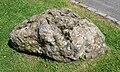 Nettlebed-paleolithic-pudding-stones.jpg 2,680 × 1,610; 1.18 MB
-
 Nettledbed Common - geograph.org.uk - 1713150.jpg 2,592 × 1,944; 2.41 MB
-
 New house on Old School Green - geograph.org.uk - 2497971.jpg 1,024 × 683; 136 KB
-
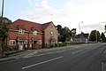
 New housing development, Nettlebed - geograph.org.uk - 1849015.jpg 1,024 × 683; 173 KB
-
 Nicholas Percival Fleming - geograph.org.uk - 5187149.jpg 533 × 800; 132 KB


.jpg)


_-_geograph.org.uk_-_6181918.jpg)


.jpg)


