Category:Neston Town Hall
Jump to navigation
Jump to search
| Object location | | View all coordinates using: OpenStreetMap |
|---|
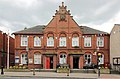
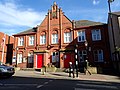
This building, on High Street, Neston, is shared by the Town Hall and the Post Office.
town hall in Neston, Cheshire West & Chester, UK  | |||||
| Upload media | |||||
| Instance of | |||||
|---|---|---|---|---|---|
| Location | Neston, Cheshire West and Chester, Cheshire, North West England, England | ||||
 | |||||
Media in category "Neston Town Hall"
The following 10 files are in this category, out of 10 total.
-
 Post box at Neston Post Office, Cheshire.jpg 3,216 × 4,734; 6.9 MB
-
 Entrance to Neston Town Hall.JPG 3,240 × 4,320; 3.27 MB
-
 Neston Town Hall 2018.jpg 4,600 × 3,018; 7.3 MB
-
 Neston Town Hall and Post Office (geograph 5686786).jpg 800 × 642; 128 KB
-
 Neston Town Hall.JPG 4,320 × 3,240; 2.77 MB
-
 Plaque, Neston Town Hall.jpg 2,984 × 2,208; 3.53 MB
-

-
 Town Hall and Post Office - geograph.org.uk - 2294420.jpg 1,200 × 844; 219 KB
-
 Town Hall and Post Office, Neston (geograph 6064198).jpg 4,000 × 3,000; 2.36 MB
-
 Town Hall, Neston - geograph.org.uk - 180569.jpg 640 × 480; 59 KB


.jpg)


.jpg)
