Category:Neponset Trail
Jump to navigation
Jump to search
2.4 mile long rail trail alongside Neponset River. Boston, Massachusetts. | |||||
| Upload media | |||||
| Instance of | |||||
|---|---|---|---|---|---|
| Location | Dorchester, Boston, Suffolk County, Massachusetts | ||||
 | |||||
Subcategories
This category has the following 2 subcategories, out of 2 total.
Media in category "Neponset Trail"
The following 17 files are in this category, out of 17 total.
-
 Butler station from mini-high, August 2016.JPG 4,320 × 3,240; 3.81 MB
-
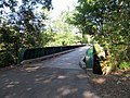 Former Baker Chocolates siding bridge, August 2016.JPG 4,320 × 3,240; 4.38 MB
-
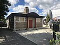 Former comfort station in Mattapan Square, Mattapan MA.jpg 4,032 × 3,024; 2.52 MB
-
 Harvest River Bridge, August 2018.JPG 5,184 × 3,888; 4.56 MB
-
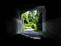 Interior of Shawmut Junction underpass, August 2016.JPG 4,320 × 3,240; 1.89 MB
-
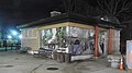 Mattapan Square Trail House night jeh.jpg 3,729 × 2,097; 1.2 MB
-
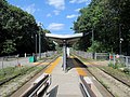
 Milton station from Adams Street, August 2016.jpg 4,427 × 2,952; 3.99 MB
-
 Milton station from Adams Street, January 2016.JPG 4,320 × 3,240; 2.45 MB
-
 Milton station from outbound streetcar (1), December 2011.jpg 4,320 × 3,240; 2.96 MB
-
 Neponset River Greenway mileage signpost, Dorchester MA.jpg 4,032 × 3,024; 4.63 MB
-
 Neponset Trail construction next to Central Avenue station, August 2016.JPG 4,320 × 3,240; 4.34 MB
-
 Neponset Trail east of Shawmut underpass in August 2016.JPG 4,320 × 3,240; 3.69 MB
-
 Neponset Trail east of Shawmut underpass, January 2016.JPG 4,320 × 3,240; 3.07 MB
-
 Neponset Trail near Ryan Playground, August 2018.jpg 5,248 × 2,952; 7.58 MB
-
 PCC streetcar on Shawmut Junction overpass, January 2016.JPG 4,320 × 3,240; 4.61 MB
-
 Shawmut Junction underpass facing east, January 2016.jpg 4,065 × 3,050; 3.28 MB
-
 Shawmut Junction underpass facing west, January 2016.JPG 4,320 × 3,240; 2.87 MB


,_December_2011.jpg)


