Category:Naturdenkmal Trockenhang Hintere Brehmenleite
Jump to navigation
Jump to search
| Object location | | View all coordinates using: OpenStreetMap |
|---|
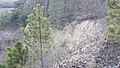
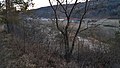
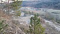
This category shows the natural monument in Tauberbischofsheim Baden-Württemberg with the ID 81281150018 and the name Trockenhang Hintere Brehmenleite.
|
 |
 |
 | |||||
| Upload media | |||||
| Instance of | |||||
|---|---|---|---|---|---|
| Location | Tauberbischofsheim, Main-Tauber-Kreis, Heilbronn-Franken, Stuttgart Government Region, Baden-Württemberg, Germany | ||||
 | |||||
Media in category "Naturdenkmal Trockenhang Hintere Brehmenleite"
The following 16 files are in this category, out of 16 total.
-
 Naturdenkmal Trockenhang Hintere Brehmenleite am Rande eines Steinbruchs - 1.jpg 4,032 × 2,268; 3.97 MB
-
 Naturdenkmal Trockenhang Hintere Brehmenleite am Rande eines Steinbruchs - 10.jpg 4,032 × 2,268; 4.44 MB
-

-
 Naturdenkmal Trockenhang Hintere Brehmenleite am Rande eines Steinbruchs - 12.jpg 4,032 × 2,268; 4.62 MB
-
 Naturdenkmal Trockenhang Hintere Brehmenleite am Rande eines Steinbruchs - 13.jpg 4,032 × 2,268; 4.33 MB
-
 Naturdenkmal Trockenhang Hintere Brehmenleite am Rande eines Steinbruchs - 14.jpg 4,032 × 2,268; 4.43 MB
-
 Naturdenkmal Trockenhang Hintere Brehmenleite am Rande eines Steinbruchs - 15.jpg 4,032 × 2,268; 5.25 MB
-
 Naturdenkmal Trockenhang Hintere Brehmenleite am Rande eines Steinbruchs - 16.jpg 4,032 × 2,268; 5.15 MB
-
 Naturdenkmal Trockenhang Hintere Brehmenleite am Rande eines Steinbruchs - 2.jpg 4,032 × 2,268; 4.16 MB
-
 Naturdenkmal Trockenhang Hintere Brehmenleite am Rande eines Steinbruchs - 3.jpg 4,032 × 2,268; 3.95 MB
-
 Naturdenkmal Trockenhang Hintere Brehmenleite am Rande eines Steinbruchs - 4.jpg 4,032 × 2,268; 4.7 MB
-
 Naturdenkmal Trockenhang Hintere Brehmenleite am Rande eines Steinbruchs - 5.jpg 4,032 × 2,268; 3.71 MB
-
 Naturdenkmal Trockenhang Hintere Brehmenleite am Rande eines Steinbruchs - 6.jpg 4,032 × 2,268; 4.94 MB
-
 Naturdenkmal Trockenhang Hintere Brehmenleite am Rande eines Steinbruchs - 7.jpg 4,032 × 2,268; 4.65 MB
-
 Naturdenkmal Trockenhang Hintere Brehmenleite am Rande eines Steinbruchs - 8.jpg 4,032 × 2,268; 5.06 MB
-
 Naturdenkmal Trockenhang Hintere Brehmenleite am Rande eines Steinbruchs - 9.jpg 4,032 × 2,268; 3.98 MB


