Category:Municipal Annexe, Liverpool
Jump to navigation
Jump to search
| Object location | | View all coordinates using: OpenStreetMap |
|---|
architectural structure in Liverpool, Merseyside, UK  | |||||
| Upload media | |||||
| Instance of | |||||
|---|---|---|---|---|---|
| Location | Liverpool, Merseyside, North West England, England | ||||
| Heritage designation |
| ||||
 | |||||
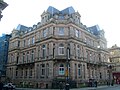
Built 1882 as Liverpool Conservative Club, then became offices for the City Council and now part of the Liverpool DoubleTree by Hilton Hotel.
Subcategories
This category has only the following subcategory.
Media in category "Municipal Annexe, Liverpool"
The following 14 files are in this category, out of 14 total.
-

-
 Municipal Annex Liverpool July 26 2010.jpg 2,304 × 3,072; 1.14 MB
-
 Municipal Annexe 04-01-2010.jpg 3,072 × 2,304; 1.21 MB
-
 Municipal Annexe balustrade 1.jpg 4,431 × 3,234; 7.61 MB
-
 Municipal Annexe balustrade 2.jpg 4,725 × 3,077; 7.55 MB
-
 Municipal Annexe door on Dale Street.jpg 3,047 × 3,894; 6.16 MB
-
 Municipal Annexe front 2018.jpg 3,947 × 3,126; 5.25 MB
-
 Municipal Annexe lamp standard.jpg 3,168 × 4,512; 6.4 MB
-
 Municipal Annexe moulding.jpg 4,514 × 3,239; 8.94 MB
-
 Municipal Annexe railings.jpg 4,903 × 3,206; 9.86 MB
-
 Municipal Annexe, Dale Street, Liverpool.JPG 1,488 × 1,984; 557 KB
-
 Municipal Annexe, Liverpool 30 April 2013 (1).jpg 1,881 × 4,288; 981 KB
-
 Municipal Annexe, Liverpool 30 April 2013 (2).jpg 2,240 × 4,288; 1,023 KB
-
 Municipal Annexe, Sir Thomas Street.jpg 3,837 × 2,983; 6.17 MB


.jpg)
.jpg)
