Category:Mudflats in Seattle, Washington
Jump to navigation
Jump to search
Media in category "Mudflats in Seattle, Washington"
The following 66 files are in this category, out of 66 total.
-
 1903 Seattle tidelands panorama (left half).jpg 3,756 × 1,939; 946 KB
-
 1903 Seattle tidelands panorama (right half).jpg 3,796 × 1,923; 899 KB
-
 1903 Seattle tidelands panorama.jpg 7,512 × 1,924; 4.63 MB
-

-
 2nd Ave and Yesler Way in 1880 and ca 1914 (SEATTLE 1781).jpg 368 × 600; 72 KB
-

-
 Anderson's 1890 map - mudflats south of King Street.jpg 820 × 1,475; 348 KB
-
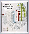 Anderson's Map of Seattle Tide Lands, circa 1907 (MOHAI 13438).jpg 1,035 × 1,200; 218 KB
-
 Asahel Curtis - panoramic view of Seattle from the tideflats, circa 1904.jpg 2,712 × 1,235; 352 KB
-

-
 Asahel Curtis panorama from Centennial Mill showing Seattle in 1902.jpg 3,141 × 582; 339 KB
-
 Asahel Curtis panorama of Seattle from Beacon Hill, 1914.jpg 2,302 × 1,089; 342 KB
-
 Asahel Curtis panorama of Seattle tideflats (1916).jpg 1,444 × 715; 163 KB
-
 Beacon Hill and First Hill from tideflats, Seattle (CURTIS 191).jpeg 682 × 512; 51 KB
-
 Beacon Hill and tideflats, Seattle (CURTIS 192).jpeg 618 × 512; 48 KB
-

-
 City of Tents, June 6, 1889 - DPLA - 62aa12754675db1ef9de6c1bd15d29b0.jpg 5,162 × 3,502; 1.2 MB
-
 Dearborn St regrade, September 18, 1909 (SEATTLE 479).jpg 768 × 586; 75 KB
-

-
 Hooverville on the Seattle tideflats, 1933 (50495168952).jpg 3,054 × 2,400; 2.26 MB
-

-
 Jackson St regrade, September 15, 1908 (SEATTLE 633).jpg 768 × 587; 72 KB
-
-
 Jackson Street Regrade, 1908 - DPLA - 09afbb4d15c39054646142b0a1b9207b.jpg 2,964 × 2,379; 838 KB
-
 Jackson Street Regrade, June 10, 1908 - DPLA - 97f4eb554efec498bc282cbabedbb9be.jpg 5,920 × 4,789; 1.41 MB
-

-

-
-

-
 Magnolia from tideflats, Seattle (CURTIS 193).jpeg 605 × 511; 43 KB
-

-
-
 Panorama of Seattle from Beacon Hill (CURTIS 88).jpeg 768 × 610; 58 KB
-

-
 Regrade activities, Seattle, ca 1908 (SEATTLE 1409).jpg 768 × 586; 93 KB
-
-
 Seattle - Lander Street sewer pipeline being built over tide flats, 1910.jpg 1,200 × 916; 339 KB
-
 Seattle bird's-eye view illustration, 1882 (SEATTLE 486).jpg 768 × 601; 139 KB
-
-

-

-

-

-

-

-
 Seattle tideflats from Beacon Hill, 1900 (SEATTLE 537).jpg 768 × 607; 82 KB
-
 Seattle tideflats viewed from Beacon Hill (CURTIS 1691).jpeg 768 × 579; 65 KB
-
 Seattle tideflats, circa 1898.jpg 3,000 × 2,024; 2.3 MB
-
 Seattle tideflats, Seattle (CURTIS 472).jpeg 768 × 606; 52 KB
-
 Seattle tideflats, Seattle (CURTIS 473).jpeg 768 × 557; 50 KB
-
 Seattle, from Beacon Hill (CURTIS 87).jpeg 768 × 621; 56 KB
-
 Seattle, Washington tide flats, 1902 (6095677130).jpg 3,807 × 1,764; 1.51 MB
-

-
 Shacks on Seattle tide flats, 1915 (49838053462).jpg 700 × 438; 63 KB
-
 Shacks on Seattle tide flats, 1915.jpg 3,862 × 2,400; 1.52 MB
-
 Shacks on the Seattle tide flats, 1915 (15119989235).jpg 3,159 × 2,400; 1.19 MB
-
 Shacks on tideflats, Seattle, 1910 (MOHAI 1025).jpg 640 × 496; 54 KB
-

-
 South-facing view of Seattle after fire, July 1889 (MOHAI 9694).jpg 679 × 555; 61 KB
-

-

-
 Tideflats, Seattle (CURTIS 194).jpeg 632 × 482; 40 KB
-
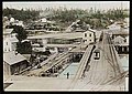
 Trestles over the tidal flats, ca 1903 (MOHAI 6104).jpg 700 × 548; 34 KB
-

-
 Waterfront and tideflats, Seattle, ca 1875 (MOHAI 1883).jpg 640 × 456; 70 KB
-
 West Garfield Street Bridge, 1930 (17088773982).jpg 1,200 × 822; 257 KB
.jpg)
.jpg)
.jpg)
.jpg)
.jpg)

.jpg)

.jpg)
.jpg)

.jpg)
.jpg)
.jpg)
.jpg)
.jpg)


.jpg)
.jpg)
.jpeg)

.jpeg)
.jpg)
.jpg)

.jpg)
.jpg)
.jpg)
.jpg)
.jpg)
.jpg)


.jpeg)
.jpeg)
.jpg)
.jpg)
.jpg)

.jpg)
.jpg)
.jpeg)
.jpg)
.jpg)
.jpeg)
.jpg)
.jpg)
.jpg)
.jpg)
.jpeg)
.jpeg)
.jpg)
.jpeg)
.jpeg)
.jpeg)
.jpg)
.jpeg)
.jpeg)
.jpeg)