Category:Mount Aspiring National Park
Jump to navigation
Jump to search
English: Mount Aspiring National Park is located in the South Island of New Zealand.
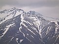
It was established in 1964 as New Zealand's 10th national park. The park covers 3,555 km² at the southern end of the Southern Alps, directly to the west of Lake Wanaka, and is popular for tramping, walking and mountaineering. Mount Aspiring/Tititea (3033 m) is the mountain which gives the park its name. Other prominent peaks within the park include Mount Pollux (2542 m) and Mount Brewster (2519 m).
national park in New Zealand  Údolí Matukituki v národním parku Mount Aspiring | |||||
| Upload media | |||||
| Instance of | |||||
|---|---|---|---|---|---|
| Part of | |||||
| Location | |||||
| IUCN protected areas category | |||||
| Inception |
| ||||
| Area |
| ||||
 | |||||
Subcategories
This category has the following 35 subcategories, out of 35 total.
B
- Blue Pools Track (12 F)
C
- Camerons Creek (1 F)
- Cascade Saddle Track (4 F)
- Courtneys Flat (2 F)
E
- Mount Earnslaw / Pikirakatahi (19 F)
F
- Fantail Falls (10 F)
- Forge Flat (2 F)
G
H
L
- Lake Harris (9 F)
- Landsborough River (2 F)
M
- Matukituki River West Branch (4 F)
- Mount Aspiring / Tititea (4 F)
- Mount Awful (6 F)
- Mount Brewster, New Zealand (4 F)
- Mount Xenicus (9 F)
P
- Pleasant Flat (17 F)
R
- Rob Roy Falls (9 F)
- Rob Roy Glacier (14 F)
- Route Burn (6 F)
T
- Thunder Creek Falls (12 F)
Y
- Young River (New Zealand) (10 F)
Media in category "Mount Aspiring National Park"
The following 9 files are in this category, out of 9 total.
-
 00 1316 Lake Wanaka - New Zealand.jpg 3,300 × 2,200; 6.24 MB
-
 Aspiring01LB.jpg 2,288 × 1,712; 798 KB
-
 Aspring02LB.jpg 3,648 × 2,736; 4.16 MB
-
 Forested valley (6706368483).jpg 3,000 × 4,000; 5.83 MB
-
 Haast Pass - panoramio (1).jpg 2,048 × 1,536; 607 KB
-
 Mount Aspiring National Park, South Island, New Zealand-6Feb2012.jpg 1,024 × 576; 388 KB
-
 Mt Aspiring VC 27.jpg 1,773 × 2,364; 409 KB
-
 Mt. Aspiring National Park banner.jpg 3,300 × 472; 1.63 MB
-
 Wanaka, New Zealand (Unsplash 10vYstR3510).jpg 3,456 × 5,184; 2.01 MB


.jpg)
.jpg)


.jpg)