Category:Moulins de Saint-Luc
Jump to navigation
Jump to search
| Object location | | View all coordinates using: OpenStreetMap |
|---|
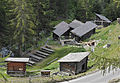
open-air museum in Saint-Luc in the canton of Valais, Switzerland  | |||||
| Upload media | |||||
| Instance of |
| ||||
|---|---|---|---|---|---|
| Part of | |||||
| Location | Saint-Luc, Anniviers, Sierre District, Valais, Switzerland | ||||
| Street address |
| ||||
| Has part(s) |
| ||||
| Heritage designation | |||||
| official website | |||||
 | |||||
Media in category "Moulins de Saint-Luc"
The following 2 files are in this category, out of 2 total.
-
 ETH-BIB-Moulins St. Luc, Anniviers-Dia 247-03274.tif 3,468 × 2,794; 27.86 MB
-
 Moulins-St-Luc-2a.jpg 4,393 × 3,028; 10.26 MB