Category:Moorswater viaduct
Jump to navigation
Jump to search
| Object location | | View all coordinates using: OpenStreetMap |
|---|
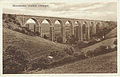
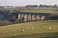
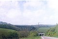
English: Moorswater viaduct carries the Cornish Main Line over a valley to the west of Liskeard railway station, Cornwall, United Kingdom. The original timber viaduct was replaced by the present structure in the 1880s. In the valley below is the site of the old Moorswater railway station of the Liskeard and Looe Railway.
viaduct in Dobwalls and Trewidland/Liskeard, Cornwall, England, UK  | |||||
| Upload media | |||||
| Instance of | |||||
|---|---|---|---|---|---|
| Location |
| ||||
| Bridge number |
| ||||
| Heritage designation |
| ||||
 | |||||
Media in category "Moorswater viaduct"
The following 23 files are in this category, out of 23 total.
-
 Moorswater Viaduct circa 1859.jpg 820 × 840; 191 KB
-
 Moorswater Viaduct.jpg 458 × 325; 48 KB
-
 Moorswater vdt 1905.jpg 471 × 303; 47 KB
-
 Moorswater Viaduct near Liskeard circa 1905.jpg 800 × 506; 82 KB
-
 2007 at Moorswater viaduct - old and new piers.jpg 1,366 × 1,024; 459 KB
-
 2013 at Moorswater station.jpg 1,024 × 683; 594 KB
-
 2013 at Moorswater Viaduct - Brunel's old pier.jpg 910 × 1,366; 716 KB
-
 2013 at Moorswater Viaduct - view from the lime kiln.jpg 1,366 × 910; 640 KB
-
 2013 at Moorswater Viaduct - view from the north east.jpg 1,366 × 910; 565 KB
-
 2013 at Moorswater Viaduct - view from the south.jpg 1,366 × 820; 494 KB
-
 Blue Pullman on Moorswater viaduct - geograph.org.uk - 762042.jpg 640 × 439; 71 KB
-
 Clay for Fowey at Coombe Junction. - geograph.org.uk - 762194.jpg 434 × 640; 85 KB
-

-
 Looe Valley Line from Trussel Bridge - geograph.org.uk - 269304.jpg 640 × 427; 129 KB
-
 Moorswater - DRS 37609.JPG 683 × 1,024; 337 KB
-
 Moorswater Viaduct - Colas 70807 westbound cement empties.JPG 1,366 × 820; 714 KB
-
 Moorswater Viaduct - CrossCountry Class 220 up train.JPG 1,366 × 820; 369 KB
-
 Moorswater Viaduct - FGW 43170 down train.JPG 1,366 × 910; 476 KB
-
 Moorswater Viaduct - geograph.org.uk - 83550.jpg 640 × 360; 123 KB
-
 Moorswater Viaduct - geograph.org.uk - 96703.jpg 640 × 423; 73 KB
-
 Moorswater Viaduct from the South - geograph.org.uk - 96717.jpg 640 × 403; 82 KB
-
 Moorswater viaduct HST.jpg 1,366 × 1,024; 511 KB
-
 The Descent to Moorswater - geograph.org.uk - 99944.jpg 640 × 433; 168 KB


