Category:Monkton Farleigh
Jump to navigation
Jump to search
village and civil parish in Wiltshire, England, UK | |||||
| Upload media | |||||
| Instance of | |||||
|---|---|---|---|---|---|
| Location | Wiltshire, South West England, England | ||||
| official website | |||||
 | |||||
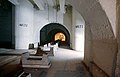
English: Monkton Farleigh is a small village in west Wiltshire, England, 3 miles (6 km) from Bradford-on-Avon, and 5 miles (8 km) from the city of Bath. It is known for its underground mines of Bath Stone, which were converted into one of the largest Ministry of Defence underground ammunition stores in the UK.
Nederlands: Monkton Farleigh is een dorp (village) en civil parish in de unitary authority Wiltshire, in het Engelse graafschap Wiltshire. De civil parish telt
Subcategories
This category has the following 4 subcategories, out of 4 total.
Media in category "Monkton Farleigh"
The following 63 files are in this category, out of 63 total.
-
 ... sheltered in Monkton Farleigh. - Flickr - BazzaDaRambler.jpg 4,340 × 3,260; 2.29 MB
-
 14 District - geograph.org.uk - 334350.jpg 640 × 413; 25 KB
-
 19 District - geograph.org.uk - 318588.jpg 640 × 480; 69 KB
-
 19 District Building. - geograph.org.uk - 318552.jpg 640 × 480; 82 KB
-

-
 Bottom of 19 District Slope Shaft - geograph.org.uk - 318599.jpg 640 × 480; 72 KB
-
 Bottom of 20 District Slope Shaft - geograph.org.uk - 318612.jpg 640 × 436; 46 KB
-
 Cottages in Monkton Farleigh - geograph.org.uk - 5273493.jpg 6,000 × 4,000; 4.18 MB
-
 Entrance to Farleigh Wick - geograph.org.uk - 3123875.jpg 640 × 480; 83 KB
-
 Entrance to Restore, Monkton Farleigh - geograph.org.uk - 5274555.jpg 6,000 × 4,000; 4.64 MB
-
 Farleigh Rise - geograph.org.uk - 5274523.jpg 6,000 × 4,000; 6.05 MB
-
 Farleigh Wick - geograph.org.uk - 107584.jpg 640 × 480; 88 KB
-
 Farm buildings at Bay's Farm - geograph.org.uk - 5273299.jpg 6,000 × 4,000; 4.59 MB
-
 Farm track near Monkton Farleigh - geograph.org.uk - 5273513.jpg 6,000 × 4,000; 4.96 MB
-
 Field of oil seed rape near Monkton Farleigh - geograph.org.uk - 5273319.jpg 6,000 × 4,000; 5.79 MB
-
 Field of oil seed rape near Pinckney Green - geograph.org.uk - 5273309.jpg 6,000 × 4,000; 5.22 MB
-
 Fields below Monkton Farleigh - geograph.org.uk - 5273520.jpg 6,000 × 4,000; 5.54 MB
-
 Footpath Monkton Farleigh - panoramio.jpg 3,456 × 4,608; 4.01 MB
-
 Footpath on Bathford Hill - geograph.org.uk - 5272399.jpg 6,000 × 4,000; 4.43 MB
-
 Footpath to Kingsdown - geograph.org.uk - 5274533.jpg 6,000 × 4,000; 5.45 MB
-
 Fox and Hounds, Farleigh Wick. - panoramio.jpg 3,248 × 2,432; 3.06 MB
-
 Harvested field near Monkton Farleigh - geograph.org.uk - 5274500.jpg 6,000 × 4,000; 3.97 MB
-
 Kingsdown Golf Club, Red course - geograph.org.uk - 781688.jpg 640 × 486; 59 KB
-
 Last rays of sunset - geograph.org.uk - 3753688.jpg 800 × 600; 364 KB
-
 Lodge Farm - geograph.org.uk - 3753680.jpg 800 × 450; 237 KB
-
 Lodge Farm - geograph.org.uk - 777833.jpg 640 × 491; 145 KB
-
 Monkton Farleigh ... the way to go. - Flickr - BazzaDaRambler.jpg 3,105 × 2,462; 1.8 MB
-
 Monkton Farleigh crossroads - geograph.org.uk - 658828.jpg 640 × 455; 95 KB
-
 Monkton Farleigh, Wiltshire ... chimney with roses. - Flickr - BazzaDaRambler.jpg 3,260 × 4,340; 3.22 MB
-
 Monkton Farleigh, Wiltshire ... gatehouse. - Flickr - BazzaDaRambler.jpg 4,328 × 3,073; 1.97 MB
-
 Monkton Farleigh, Wiltshire ... post office window. - Flickr - BazzaDaRambler.jpg 4,340 × 3,260; 2.67 MB
-
 November sunset - geograph.org.uk - 3753687.jpg 800 × 450; 258 KB
-
 Ordnance Survey Cut Mark - geograph.org.uk - 4848717.jpg 640 × 360; 76 KB
-
 Ordnance Survey Cut Mark - geograph.org.uk - 4849622.jpg 4,000 × 3,000; 4.62 MB
-
 Path on Bathford Hill - geograph.org.uk - 3186885.jpg 1,920 × 1,279; 2.87 MB
-
 Path on the side of Bathford Hill - geograph.org.uk - 5272387.jpg 6,000 × 4,000; 6.94 MB
-
 Road junction in Monkton Farleigh - geograph.org.uk - 5273491.jpg 6,000 × 4,000; 5.13 MB
-
 Road through Warleigh Wood - geograph.org.uk - 209887.jpg 480 × 640; 94 KB
-
 Road to Monkton Farleigh - geograph.org.uk - 5645846.jpg 640 × 480; 64 KB
-
 Rushmead Farm - geograph.org.uk - 777876.jpg 640 × 473; 91 KB
-
 Rushmead Farm entrance - geograph.org.uk - 781769.jpg 640 × 512; 85 KB
-
 Sycamore leaves - geograph.org.uk - 3753686.jpg 800 × 450; 354 KB
-

-
 The end of Farleigh Rise - geograph.org.uk - 5274514.jpg 6,000 × 4,000; 5.43 MB
-
 The King's Arms - geograph.org.uk - 658856.jpg 640 × 426; 94 KB
-
 The top of Prospect Place - geograph.org.uk - 3753691.jpg 800 × 600; 343 KB
-
 Upper or lower case in the signage^ - geograph.org.uk - 5454887.jpg 1,600 × 1,065; 626 KB
-
 View From A 'Hole' - geograph.org.uk - 6054650.jpg 681 × 1,024; 246 KB
-
 View of Fields - geograph.org.uk - 3104396.jpg 4,598 × 2,805; 3.61 MB
-
 Village store and Post Office - geograph.org.uk - 658842.jpg 640 × 413; 93 KB
-
 Wheat field at Monkton Farleigh - geograph.org.uk - 5273501.jpg 6,000 × 4,000; 5.66 MB
-
 Wheat field by Bay's Farm - geograph.org.uk - 5273304.jpg 6,000 × 4,000; 4.53 MB
-
 Wheat field near Bay's Farm - geograph.org.uk - 5273291.jpg 6,000 × 4,000; 4.61 MB
-
 Wheat fields near Monkton Farleigh - geograph.org.uk - 5274545.jpg 6,000 × 4,000; 4.81 MB
-
 White van, golden leaves - geograph.org.uk - 3753684.jpg 800 × 450; 330 KB
-
 Wooded hillside on Bathford Hill - geograph.org.uk - 5272720.jpg 6,000 × 4,000; 5.21 MB
-
 Lower Kingsdown Road (2) - geograph.org.uk - 658991.jpg 640 × 459; 96 KB
-
 Lower Kingsdown Road - geograph.org.uk - 137468.jpg 640 × 480; 124 KB
-
 North east of Monkton Farleigh - geograph.org.uk - 657934.jpg 640 × 423; 61 KB
-
 Off Lower Kingsdown Road - geograph.org.uk - 658967.jpg 640 × 426; 97 KB
-
 The Old School - geograph.org.uk - 658855.jpg 640 × 446; 77 KB
-
 The Road to Wraxall (2) - geograph.org.uk - 658848.jpg 640 × 470; 105 KB
-
 The Road to Wraxall - geograph.org.uk - 658835.jpg 640 × 452; 105 KB


_-_geograph.org.uk_-_658991.jpg)


_-_geograph.org.uk_-_658848.jpg)
