Category:Mittenwalde (Uckermark)
Jump to navigation
Jump to search
municipality in Brandenburg state, Germany _2017_NE.jpg)  | |||||
| Upload media | |||||
| Instance of |
| ||||
|---|---|---|---|---|---|
| Named after |
| ||||
| Location | Uckermark District, Brandenburg, Germany | ||||
| Street address |
| ||||
| Population |
| ||||
| Area |
| ||||
| Elevation above sea level |
| ||||
| Different from | |||||
| official website | |||||
 | |||||
Subcategories
This category has the following 3 subcategories, out of 3 total.
B
C
Media in category "Mittenwalde (Uckermark)"
The following 30 files are in this category, out of 30 total.
-

-
 Aufgegebene Kaufhalle in Mittenwalde (Uckermark) 2017.jpg 4,864 × 3,648; 5.87 MB
-
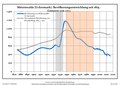 Bevölkerungsentwicklung Mittenwalde (Uckermark).pdf 1,752 × 1,239; 120 KB
-
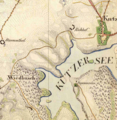
 Blankensee Kienwerder Krullenhaus Urmesstischblatt 2848-1826.png 1,605 × 1,209; 4.1 MB
-
De-Mittenwalde.ogg 2.3 s; 21 KB
-
 Field in Mittenwalde 2021-05-29.jpg 8,368 × 5,584; 16.91 MB
-
 Kienw.Gutsh.JPG 3,139 × 2,061; 2.9 MB
-
 Kienwerder.JPG 1,600 × 1,013; 493 KB
-
 Kuhz Ruhhof Pappelwerder Urmesstischblatt 2747-1825.png 1,385 × 1,425; 3.76 MB
-
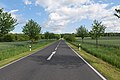
 L24 in Mittenwalde 2021-05-29 01.jpg 8,368 × 5,584; 23.42 MB
-
 L24 in Mittenwalde 2021-05-29 02.jpg 8,368 × 5,584; 24.11 MB
-
 L24 in Mittenwalde 2021-05-29 03.jpg 8,368 × 5,584; 24.26 MB
-
 L24 in Mittenwalde 2021-05-29 04.jpg 8,368 × 5,584; 20.22 MB
-
 L24 in Mittenwalde 2021-05-29 05.jpg 8,368 × 5,584; 20.69 MB
-
 L24 in Mittenwalde 2021-05-29 06.jpg 8,368 × 5,584; 20.42 MB
-
 L24 in Mittenwalde 2021-05-29 07.jpg 8,368 × 5,584; 21.87 MB
-
 L24 in Mittenwalde 2021-05-29 08.jpg 8,368 × 5,584; 22.66 MB
-
 L24 in Mittenwalde 2021-05-29 09.jpg 8,368 × 5,584; 22.97 MB
-
 L24 in Mittenwalde 2021-05-29 10.jpg 8,368 × 5,584; 22.8 MB
-
 L24 in Mittenwalde 2021-05-29 11.jpg 8,368 × 5,584; 23.45 MB
-
 L24 in Mittenwalde 2021-05-29 12.jpg 8,368 × 5,584; 22.83 MB
-
 L24 in Mittenwalde 2021-05-29 13.jpg 8,368 × 5,584; 24.75 MB
-
 L24 in Mittenwalde 2021-05-29 14.jpg 8,368 × 5,584; 22.66 MB
-
 L24 in Mittenwalde 2021-05-29 15.jpg 8,368 × 5,584; 23.6 MB
-
 Mittenwalde in UM.png 299 × 299; 6 KB
-
 Street in Mittenwalde 2021-05-29 01.jpg 8,368 × 5,584; 24.57 MB
-
 Street in Mittenwalde 2021-05-29 02.jpg 8,368 × 5,584; 23.59 MB
-
 Street in Mittenwalde 2021-05-29 03.jpg 8,368 × 5,584; 24.05 MB
-
 Street in Mittenwalde 2021-05-29 04.jpg 8,368 × 5,584; 24.04 MB
-
 Trebowsee Wiedebusch Urmesstischblatt 2747-1825.png 1,981 × 1,241; 4.78 MB

_2017.jpg)


