Category:Mitteldorf 43 (Schoppernau)
Jump to navigation
Jump to search
| Object location | | View all coordinates using: OpenStreetMap |
|---|
human settlement in Austria  | |||||
| Upload media | |||||
| Instance of | |||||
|---|---|---|---|---|---|
| Location | Schoppernau, Bregenz District, Vorarlberg, Austria | ||||
| Street address |
| ||||
| Heritage designation | |||||
 | |||||
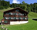
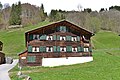
Deutsch: aus dem DEHIO Vorarlberg 1983: Schoppernau, BAUERNHÖFE: Großteils spätes 18. und 1.Hälfte 19. Jhs. beziehungsweise im 19. Jh. ausgbaut, die Wohnteile verschindelte Blockbauten mit 4- bis 6achsigen Giebelfronten und traufseitig offenem Schopf. Ensembles bilden im Ortskern Nr. 12-19 (Nr.14 mit breiter 7achsiger Giebelfront, Ende des 19 Jhs. ausgebaut) und Nr.25,26,28; am östlichen Dorfrand Nr. 62-65 und Nr.67. Nr.43: Einhof, Wohnteil bezeichnet 1786, Blockbau auf Kellersockel, zum Teil mit Bretterschirm, traufseitig offener Schopf, Pfettenunterzüge, Ochsenblutanstrich und Rokokomalerei.
| This category shows the protected monument with the number 18724 in Austria. (Commons, de, Wikidata) |
Quelle: Dehio Vorarlberg
Media in category "Mitteldorf 43 (Schoppernau)"
The following 3 files are in this category, out of 3 total.
-
 Schoppernau Mitteldorf 43.JPG 5,989 × 4,841; 19.49 MB
-
 Schoppernau, Mitteldorf 43 2.JPG 7,360 × 4,912; 25.85 MB
-
 Schoppernau, Mitteldorf 43 3.JPG 7,360 × 4,912; 11.19 MB

