Category:Michaelskapelle (Rottenmann)
Jump to navigation
Jump to search
| This category shows the protected monument with the number 97796 in Austria. (Commons, de, Wikidata) |
| Object location | | View all coordinates using: OpenStreetMap |
|---|
building in Rottenmann, Austria  | |||||
| Upload media | |||||
| Instance of | |||||
|---|---|---|---|---|---|
| Location | Rottenmann, Liezen District, Styria, Austria | ||||
| Street address |
| ||||
| Heritage designation | |||||
 | |||||
Media in category "Michaelskapelle (Rottenmann)"
The following 4 files are in this category, out of 4 total.
-
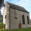 Rottenmann Michaelskapelle.jpg 2,321 × 2,321; 2.27 MB
-
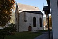 Rottenmann-old Church-01ASD.jpg 4,592 × 3,056; 5.19 MB
-
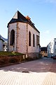 Rottenmann-old Church-02ASD.jpg 3,056 × 4,592; 1.31 MB
-
 Stadtpfarrkirche St. Nikolaus Rottenmann 02.jpg 4,000 × 6,000; 11.83 MB


