Category:Mauger Caye Light
Jump to navigation
Jump to search
| Object location | | View all coordinates using: OpenStreetMap |
|---|
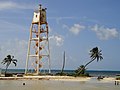
English: Mauger Caye Light
lighthouse in Belize .jpg) | |||||
| Upload media | |||||
| Instance of | |||||
|---|---|---|---|---|---|
| Location | Belize District, Belize | ||||
| Inception |
| ||||
| Source of energy | |||||
| Height |
| ||||
 | |||||
Media in category "Mauger Caye Light"
The following 5 files are in this category, out of 5 total.
-
 The Lighthouse Turneffe Atoll (4866298466).jpg 2,736 × 3,648; 6.55 MB
-
 Turneffe lighthouse (4906563450).jpg 3,648 × 2,736; 3.87 MB
-
 Turneffe lighthouse (4906649282).jpg 3,046 × 1,716; 667 KB
-
 Turneffe Lighthouse - Pano (4905976787).jpg 7,152 × 1,080; 2.77 MB
-
 Turneffe Lighthouse and divemaster (4925346966).jpg 1,920 × 576; 921 KB
.jpg)
.jpg)
.jpg)
.jpg)